ISS044-E-1998

| NASA Photo ID | ISS044-E-1998 |
| Focal Length | 1150mm |
| Date taken | 2015.06.19 |
| Time taken | 12:34:35 GMT |
Resolutions offered for this image:
1000 x 860 pixels 540 x 464 pixels 4928 x 3280 pixels 720 x 480 pixels 720 x 480 pixels 4928 x 3280 pixels 640 x 426 pixels
1000 x 860 pixels 540 x 464 pixels 4928 x 3280 pixels 720 x 480 pixels 720 x 480 pixels 4928 x 3280 pixels 640 x 426 pixels


Spacecraft nadir point: 35.7° N, 10.7° E
Photo center point: 34.7° N, 10.8° E
Photo center point by machine learning:
Photo center point: 34.7° N, 10.8° E
Photo center point by machine learning:
Nadir to Photo Center: South
Spacecraft Altitude: 213 nautical miles (394km)
Country or Geographic Name: | TUNISIA |
Features: | SFAX, PORT FACILITIES, SALT PONDS |
| Features Found Using Machine Learning: | |
Cloud Cover Percentage: | 10 (1-10)% |
Sun Elevation Angle: | 70° |
Sun Azimuth: | 239° |
Camera: | Nikon D4 Electronic Still Camera |
Focal Length: | 1150mm |
Camera Tilt: | 16 degrees |
Format: | 4928E: 4928 x 3280 pixel CMOS sensor, 36.0mm x 23.9mm, total pixels: 16.6 million, Nikon FX format |
Film Exposure: | |
| Additional Information | |
| Width | Height | Annotated | Cropped | Purpose | Links |
|---|---|---|---|---|---|
| 1000 pixels | 860 pixels | No | Yes | Earth From Space collection | Download Image |
| 540 pixels | 464 pixels | Yes | Yes | Earth From Space collection | Download Image |
| 4928 pixels | 3280 pixels | No | No | NASA's Earth Observatory web site | Download Image |
| 720 pixels | 480 pixels | Yes | Yes | NASA's Earth Observatory web site | Download Image |
| 720 pixels | 480 pixels | Yes | Yes | NASA's Earth Observatory web site | Download Image |
| 4928 pixels | 3280 pixels | No | No | Download Image | |
| 640 pixels | 426 pixels | No | No | Download Image |
Download Packaged File
Download a Google Earth KML for this Image
View photo footprint information
Download a GeoTIFF for this photo
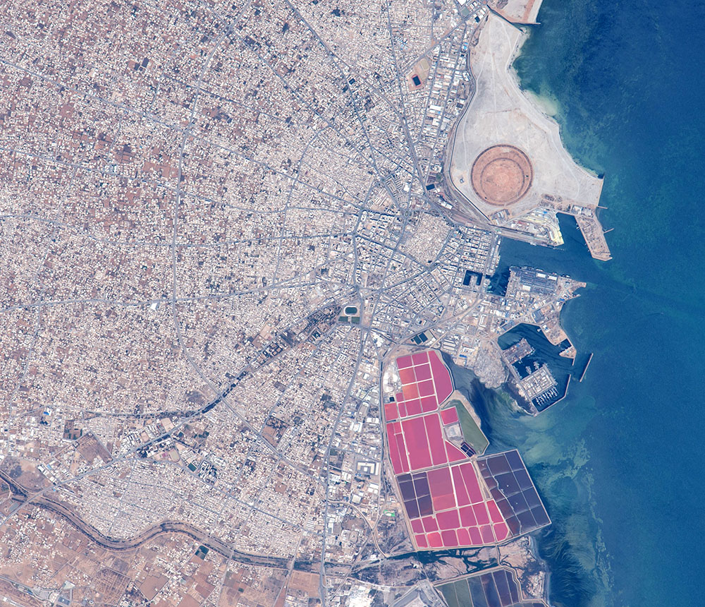
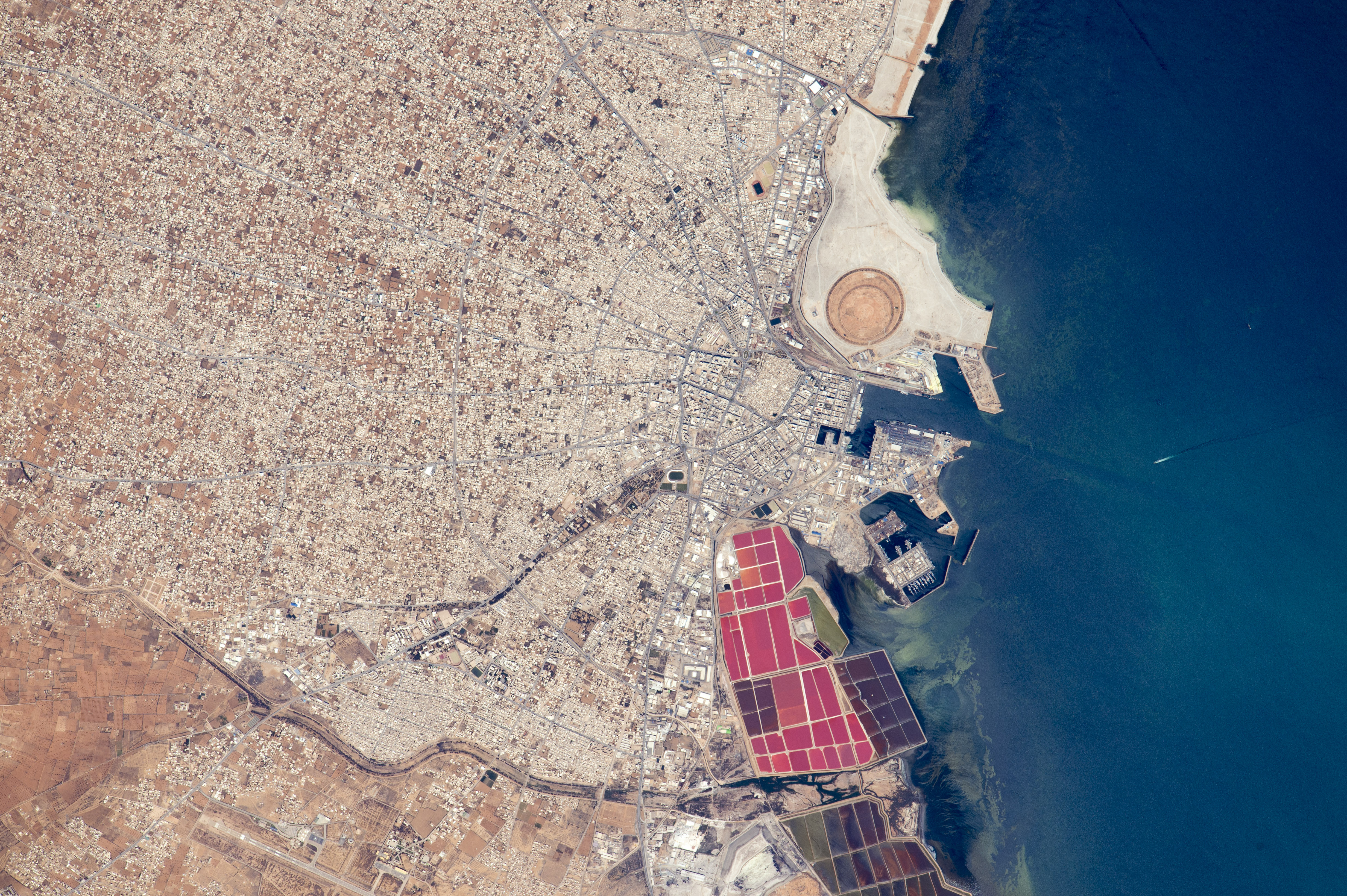
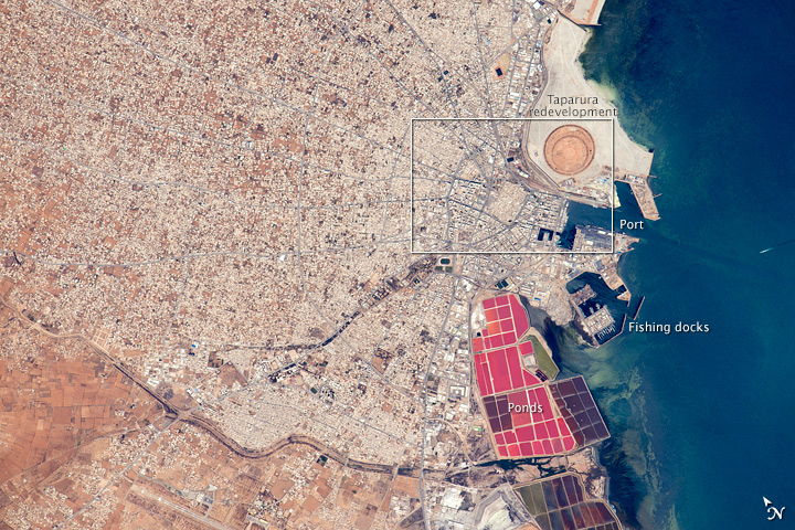
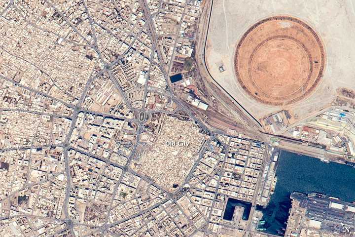
Image Caption: The port of Sfax, Tunisia
Astronauts aboard the International Space Station took this detailed image of the radiating street pattern of Tunisia's second city and major port of Sfax (population ~900,000), that also hosts Tunisia's largest fishing fleet (for scale the fishing port is 1.1 km long). The radial street pattern focuses on the ancient walled city (the "medina"--image center) with its distinct pattern as seen from orbit of small blocks and narrow streets, and even a slight color difference of the rooftops. A river winds across the lower left of the image.
More detailed visual cues that tell astronauts they are overflying Sfax are the brilliantly colored salt ponds south of the old city and the new circular earth works of the Taparura redevelopment project just north of the old city. Named after the town in antiquity on which Sfax now stands, the redevelopment has reclaimed many hectares along 5 km of shoreline (extending outside the image) and reengineered a polluted and marshy area on the coastal side of the long curve of the city's railroad tracks.
