ISS022-E-78463
| NASA Photo ID | ISS022-E-78463 |
| Focal Length | mm |
| Date taken | 2010.02.28 |
| Time taken | 10:34:12 GMT |
Resolutions offered for this image:
1000 x 742 pixels 540 x 401 pixels 720 x 480 pixels 4256 x 2913 pixels 640 x 438 pixels
1000 x 742 pixels 540 x 401 pixels 720 x 480 pixels 4256 x 2913 pixels 640 x 438 pixels

Cloud masks available for this image:
Spacecraft nadir point: 29.4° N, 94.1° W
Photo center point: 30.0° N, 95.0° W
Photo center point by machine learning:
Photo center point: 30.0° N, 95.0° W
Photo center point by machine learning:
Nadir to Photo Center: Northwest
Spacecraft Altitude: 189 nautical miles (350km)
Country or Geographic Name: | USA-TEXAS |
Features: | HOUSTON-GALVESTON AREA AT NIGHT |
| Features Found Using Machine Learning: | |
Cloud Cover Percentage: | 0 (no clouds present) |
Sun Elevation Angle: | -29° |
Sun Azimuth: | 83° |
Camera: | Nikon D3 Electronic Still Camera |
Focal Length: | mm |
Camera Tilt: | 19 degrees |
Format: | 4256E: 4256 x 2832 pixel CMOS sensor, 36.0mm x 23.9mm, total pixels: 12.87 million, Nikon FX format |
Film Exposure: | |
| Additional Information | |
| Width | Height | Annotated | Cropped | Purpose | Links |
|---|---|---|---|---|---|
| 1000 pixels | 742 pixels | No | Yes | Earth From Space collection | Download Image |
| 540 pixels | 401 pixels | Yes | Yes | Earth From Space collection | Download Image |
| 720 pixels | 480 pixels | Yes | Yes | NASA's Earth Observatory web site | Download Image |
| 4256 pixels | 2913 pixels | No | No | Download Image | |
| 640 pixels | 438 pixels | No | No | Download Image |
Download Packaged File
Download a Google Earth KML for this Image
View photo footprint information
Download a GeoTIFF for this photo
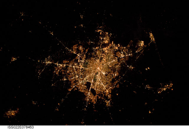
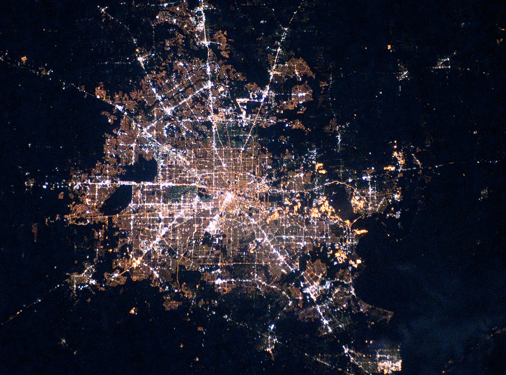
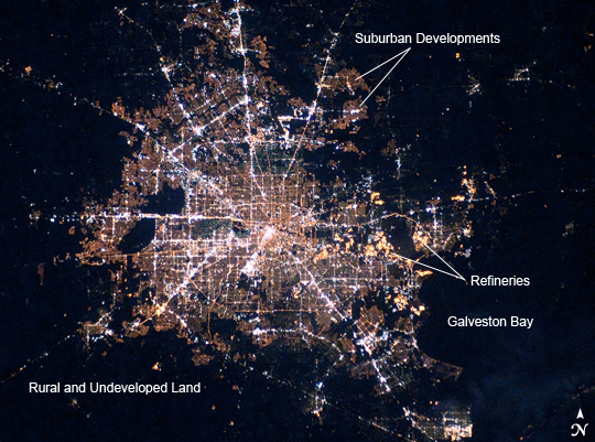
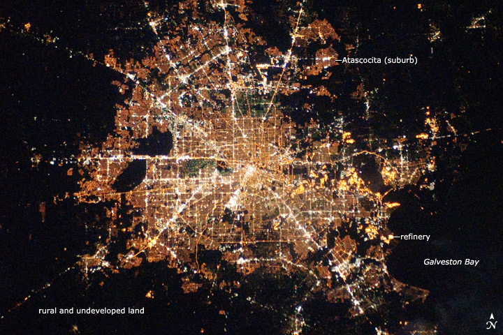
Image Caption: Houston, Texas at Night
Houston, Texas has been called the "energy capital of the world" due to its role as a major hub of the petroleum and other energy resource industries. The Houston metropolitan area covers almost 2,331,000 hectares (9,000 square miles) along the southeast Texas coastline, with an average elevation of 13 meters (43 feet) above sea level and a population of over 5 million (2006 US Census estimate). The Houston metropolitan area is also noteworthy as being the largest in the United States without formal zoning restrictions. This has led to a highly diverse pattern of land use at the neighborhood scale; nevertheless, more general spatial patterns of land use can be recognized in remotely sensed data. This is particularly evident in nighttime photography of the urban area taken by astronauts on board the International Space Station.
The image depicts the roughly 100 kilometer (60 mile) east-west extent of the Houston metropolitan area. Houston proper is at image center, indicated by a "bull's-eye" of elliptical white to orange-lighted beltways and brightly lit white freeways radiating outwards from the central downtown area. Suburban and primarily residential urban land uses are indicated by both reddish-brown and gray-green lighted regions that reflect a higher proportion of tree cover and lower light density. Petroleum refineries along the Houston Ship Channel are identified by densely lit areas of golden yellow light. Rural and undeveloped land rings the metropolitan area, and Galveston Bay to the southeast (image lower right) provides access to the Gulf of Mexico. Both types of non-urban surface appear dark in the image.
You can see more nighttime imagery of cities, and learn about techniques that astronauts use to photograph them in the Earth Observatory feature Cities at Night.
