ISS015-E-5483

| NASA Photo ID | ISS015-E-5483 |
| Focal Length | 800mm |
| Date taken | 2007.04.28 |
| Time taken | 17:20:15 GMT |
Resolutions offered for this image:
1000 x 737 pixels 540 x 398 pixels 540 x 405 pixels 3032 x 2064 pixels 639 x 435 pixels
1000 x 737 pixels 540 x 398 pixels 540 x 405 pixels 3032 x 2064 pixels 639 x 435 pixels

Cloud masks available for this image:
Spacecraft nadir point: 41.7° N, 72.3° W
Photo center point: 40.6° N, 74.0° W
Photo center point by machine learning:
Photo center point: 40.6° N, 74.0° W
Photo center point by machine learning:
Nadir to Photo Center: Southwest
Spacecraft Altitude: 174 nautical miles (322km)
Camera: | Kodak DCS760c Electronic Still Camera |
Focal Length: | 800mm |
Camera Tilt: | 35 degrees |
Format: | 3060E: 3060 x 2036 pixel CCD, RGBG array |
Film Exposure: | |
| Additional Information | |
| Width | Height | Annotated | Cropped | Purpose | Links |
|---|---|---|---|---|---|
| 1000 pixels | 737 pixels | No | Yes | Earth From Space collection | Download Image |
| 540 pixels | 398 pixels | Yes | Yes | Earth From Space collection | Download Image |
| 540 pixels | 405 pixels | Yes | Yes | NASA's Earth Observatory web site | Download Image |
| 3032 pixels | 2064 pixels | No | No | Download Image | |
| 639 pixels | 435 pixels | No | No | Download Image |
Download Packaged File
Download a Google Earth KML for this Image
View photo footprint information
Download a GeoTIFF for this photo
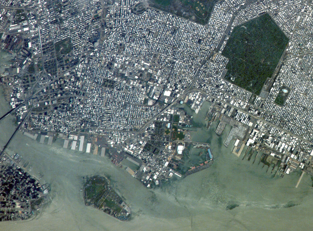
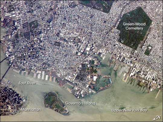
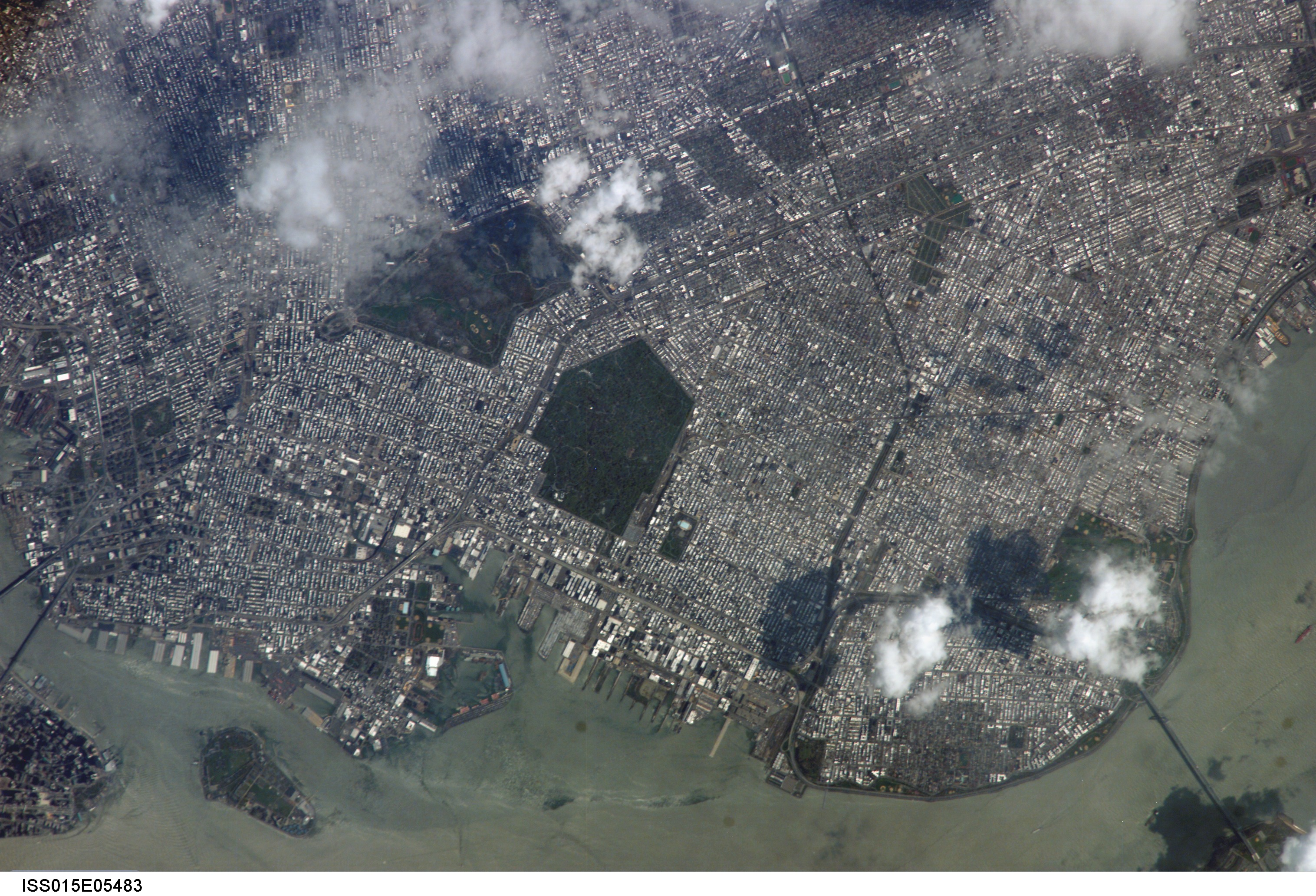
Image Caption: ISS015-E-05483 (28 April 2007) --- Brooklyn, New York waterfront is featured in this image photographed by an Expedition 15 crewmember on the International Space Station. This view illustrates the dense urban fabric of Brooklyn, New York City's largest borough (population of 2.6 million), characterized by the regular pattern of highly reflective building rooftops (white). Two main arteries from Manhattan into Brooklyn, the famous Brooklyn Bridge and neighboring Manhattan Bridge, cross the East River along the left (north) side of the image. The dense built-up fabric contrasts with the East River and Upper New York Bay (bottom center) waterfront areas, recognizable by docks and large industrial loading facilities that extend across the bottom center from left to right. Much of the shipping traffic has moved to the New Jersey side of New York Bay--this has spurred dismantling and redevelopment of the historic dockyards and waterfront warehouses into residential properties. However, efforts to conserve historic buildings are also ongoing. The original name for Brooklyn, Breukelen, means "broken land" in Dutch--perhaps in recognition of the highly mixed deposits (boulders, sand, silt, and clay) left behind by the Wisconsin glacier between 20,000--90,000 years ago, according to scientists. These deposits form much of Long Island, of which Brooklyn occupies the western tip. This image features one of Brooklyn's largest green spaces, the Green-Wood Cemetery. Today, the cemetery functions as both a natural park and a place of internment. The green tree canopy of the Cemetery contrasts sharply with the surrounding urban land cover, is an Audubon Sanctuary, and provides the final resting place for many 19th and 20th century New York celebrities. Also visible in the image is Governor's Island, which served as a strategic military installation for the US Army (1783--1966) and a major US Coast Guard installation (1966--1996). Today the historic fortifications on the island and their surroundings comprise the Governors Island National Monument.
Brooklyn, New York Waterfront:
This astronaut photograph captures the dense urban fabric of Brooklyn, New York City's largest borough (population of 2.6 million), characterized by the regular pattern of highly reflective building rooftops (white). Two main arteries from Manhattan into Brooklyn--the famous Brooklyn Bridge and neighboring Manhattan Bridge--cross the East River along the left (north) side of the image. The densely built-up landscape contrasts with the East River and Upper New York Bay (image lower right) waterfront areas, recognizable by docks and large industrial loading facilities that extend across the image center from left to right. Much of the shipping traffic has moved to the New Jersey side of New York Bay, a shift that has spurred dismantling and redevelopment of the historic dockyards and waterfront warehouses into residential properties. However, efforts to conserve historic buildings are also ongoing.
The original name for Brooklyn, Breukelen, means "broken land" in Dutch, perhaps in recognition of the highly mixed deposits (boulders, sand, silt, and clay) left behind by the Wisconsin glacier between 20,000 and 90,000 years ago. These deposits form much of Long Island, of which Brooklyn occupies the western tip. This image features one of Brooklyn's largest green spaces, the Green-Wood Cemetery. The green canopy of the cemetery's trees contrasts sharply with the surrounding urban land cover. Today, the cemetery also functions as a natural park, and it is an Audubon Sanctuary. Also visible in the image is Governors Island, which served as a strategic military installation for the U.S. Army (1783-1966) and a major U.S. Coast Guard installation (1966-1996). Today the historic fortifications on the island and their surroundings comprise the Governors Island National Monument.
