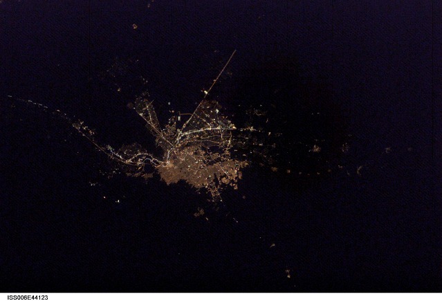
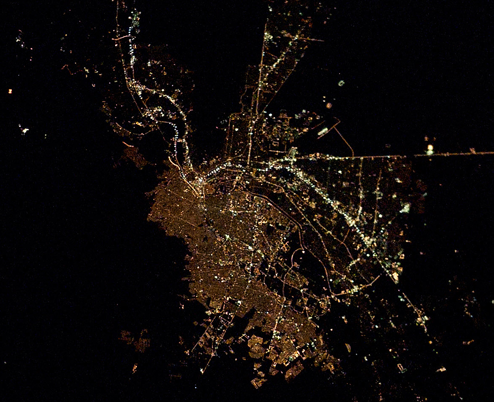
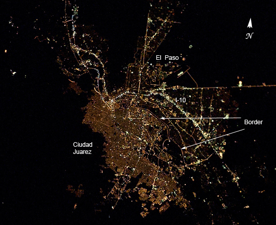
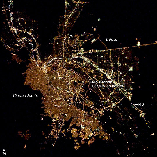
ISS006-E-44123
| NASA Photo ID | ISS006-E-44123 |
| Focal Length | 85mm |
| Date taken | 2003.04.07 |
| Time taken | 05:15:49 GMT |
Resolutions offered for this image:
1000 x 815 pixels 540 x 440 pixels 540 x 540 pixels 3032 x 2064 pixels 639 x 435 pixels
1000 x 815 pixels 540 x 440 pixels 540 x 540 pixels 3032 x 2064 pixels 639 x 435 pixels
Cloud masks available for this image:
Spacecraft nadir point: 31.4° N, 106.0° W
Photo center point: 32.0° N, 106.5° W
Photo center point by machine learning:
Photo center point: 32.0° N, 106.5° W
Photo center point by machine learning:
Nadir to Photo Center: Northwest
Spacecraft Altitude: 210 nautical miles (389km)
Country or Geographic Name: | USA-NEW MEXICO |
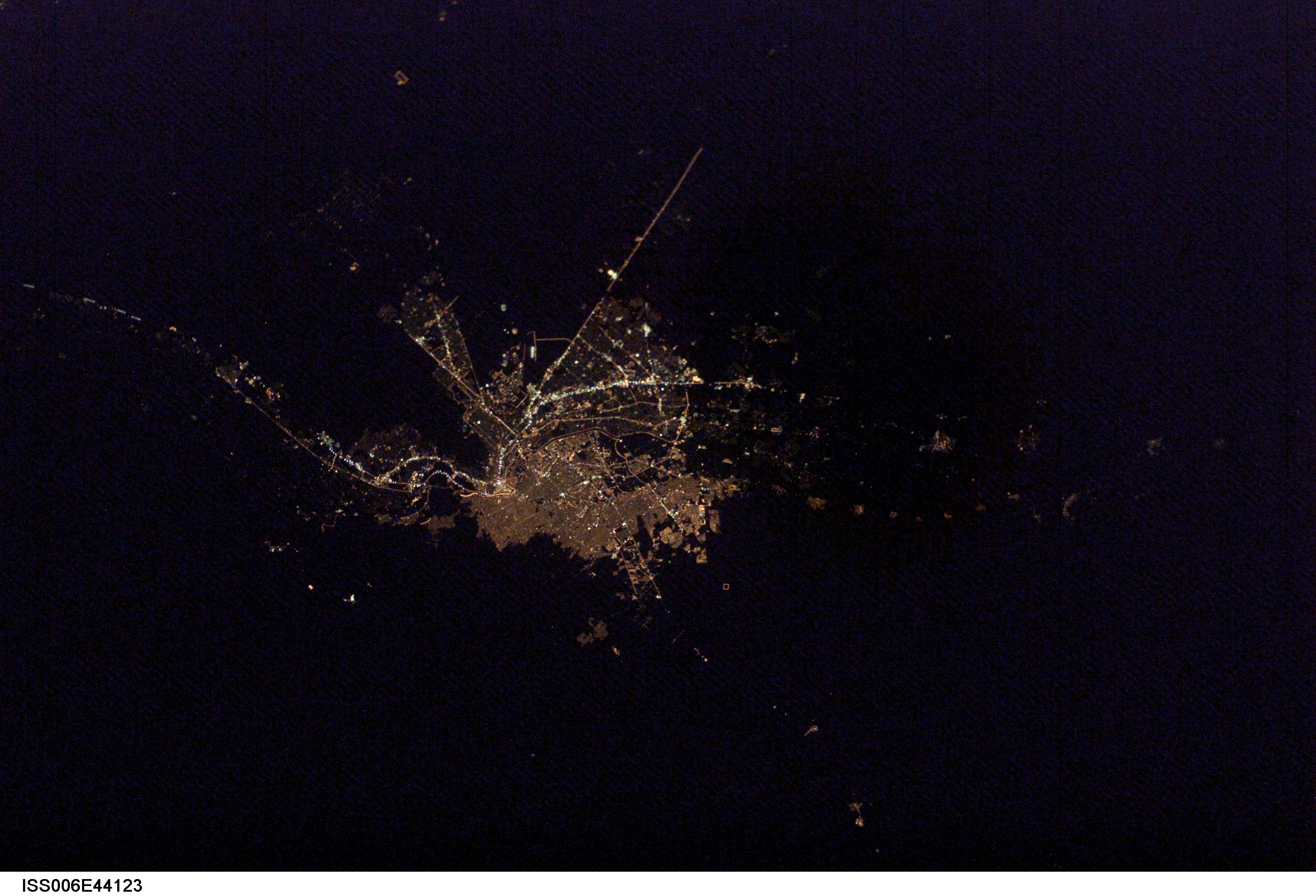
Features: | EL PASO AT NIGHT |
| Features Found Using Machine Learning: | |
Cloud Cover Percentage: | 0 (no clouds present) |
Sun Elevation Angle: | -44° |
Sun Azimuth: | 320° |
Camera: | Kodak DCS760c Electronic Still Camera |
Focal Length: | 85mm |
Camera Tilt: | 13 degrees |
Format: | 3060E: 3060 x 2036 pixel CCD, RGBG array |
Film Exposure: | |
| Additional Information | |
| Width | Height | Annotated | Cropped | Purpose | Links |
|---|---|---|---|---|---|
| 1000 pixels | 815 pixels | No | Yes | Earth From Space collection | Download Image |
| 540 pixels | 440 pixels | Yes | Yes | Earth From Space collection | Download Image |
| 540 pixels | 540 pixels | Yes | Yes | NASA's Earth Observatory web site | Download Image |
| 3032 pixels | 2064 pixels | No | No | Download Image | |
| 639 pixels | 435 pixels | No | No | Download Image |
Download Packaged File
Download a Google Earth KML for this Image
View photo footprint information
Download a GeoTIFF for this photo
Image Caption: Lights across the border: Ciudad Juarez, across the US-Mexico border from El Paso, Texas, supports at least 1,300,000 people. On the U.S. side of the Rio Grande, El Paso is marked by the brightly-lit Interstate Highway I-10 that cuts across the city. Although the area of El Paso, with an estimated population of slightly more than 600,000 is roughly on the order of the area of built-up Ciudad Juarez, the density of settlement evidenced by the distribution of lights, is much less.
