< ISS009-E-9987 >

| NASA Photo ID | ISS009-E-9987 |
| Focal Length | 180mm |
| Date taken | 2004.06.03 |
| Time taken | 12:23:21 GMT |
Resolutions offered for this image:
3032 x 2064 pixels 1200 x 816 pixels 540 x 405 pixels 3032 x 2064 pixels 639 x 435 pixels
3032 x 2064 pixels 1200 x 816 pixels 540 x 405 pixels 3032 x 2064 pixels 639 x 435 pixels


Spacecraft nadir point: 41.7° N, 1.8° E
Photo center point: 41.5° N, 2.0° E
Photo center point by machine learning:
Photo center point: 41.5° N, 2.0° E
Photo center point by machine learning:
Nadir to Photo Center: Southeast
Spacecraft Altitude: 194 nautical miles (359km)
Camera: | Kodak DCS760c Electronic Still Camera |
Focal Length: | 180mm |
Camera Tilt: | 5 degrees |
Format: | 3060E: 3060 x 2036 pixel CCD, RGBG array |
Film Exposure: | |
| Additional Information | |
| Width | Height | Annotated | Cropped | Purpose | Links |
|---|---|---|---|---|---|
| 3032 pixels | 2064 pixels | No | No | Cities collection | Download Image |
| 1200 pixels | 816 pixels | No | No | Cities collection | Download Image |
| 540 pixels | 405 pixels | Yes | Yes | NASA's Earth Observatory web site | Download Image |
| 3032 pixels | 2064 pixels | No | No | Download Image | |
| 639 pixels | 435 pixels | No | No | Download Image |
Download Packaged File
Download a Google Earth KML for this Image
View photo footprint information
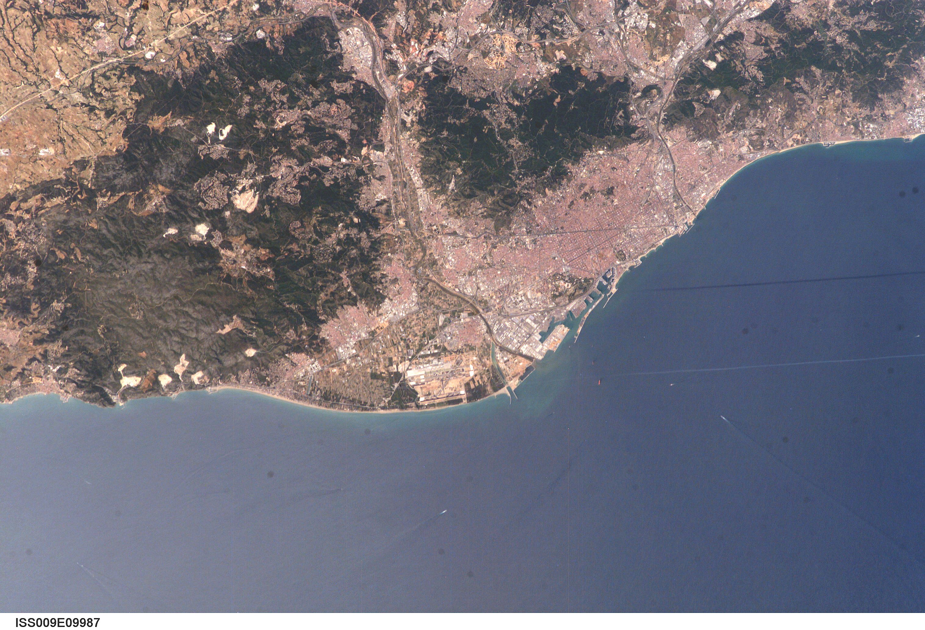
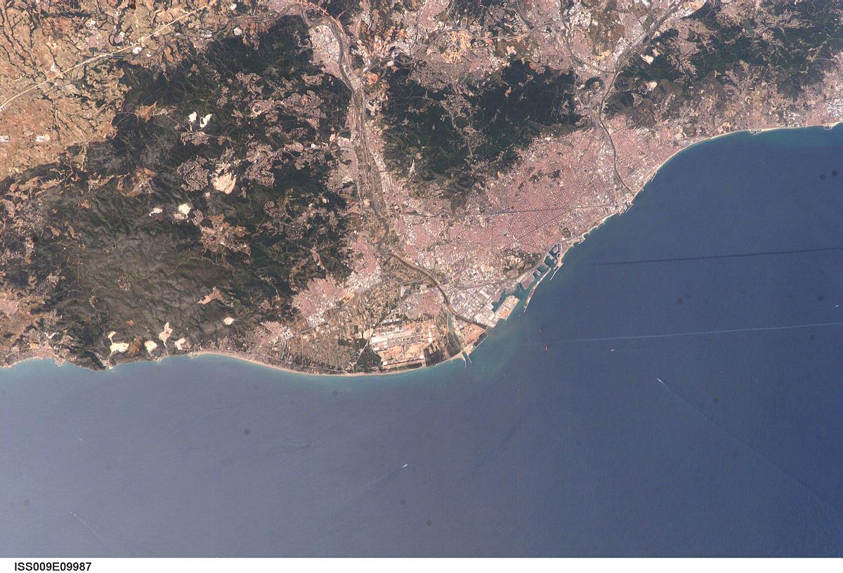
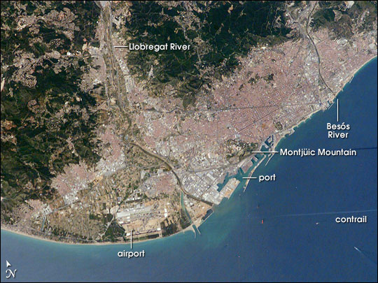
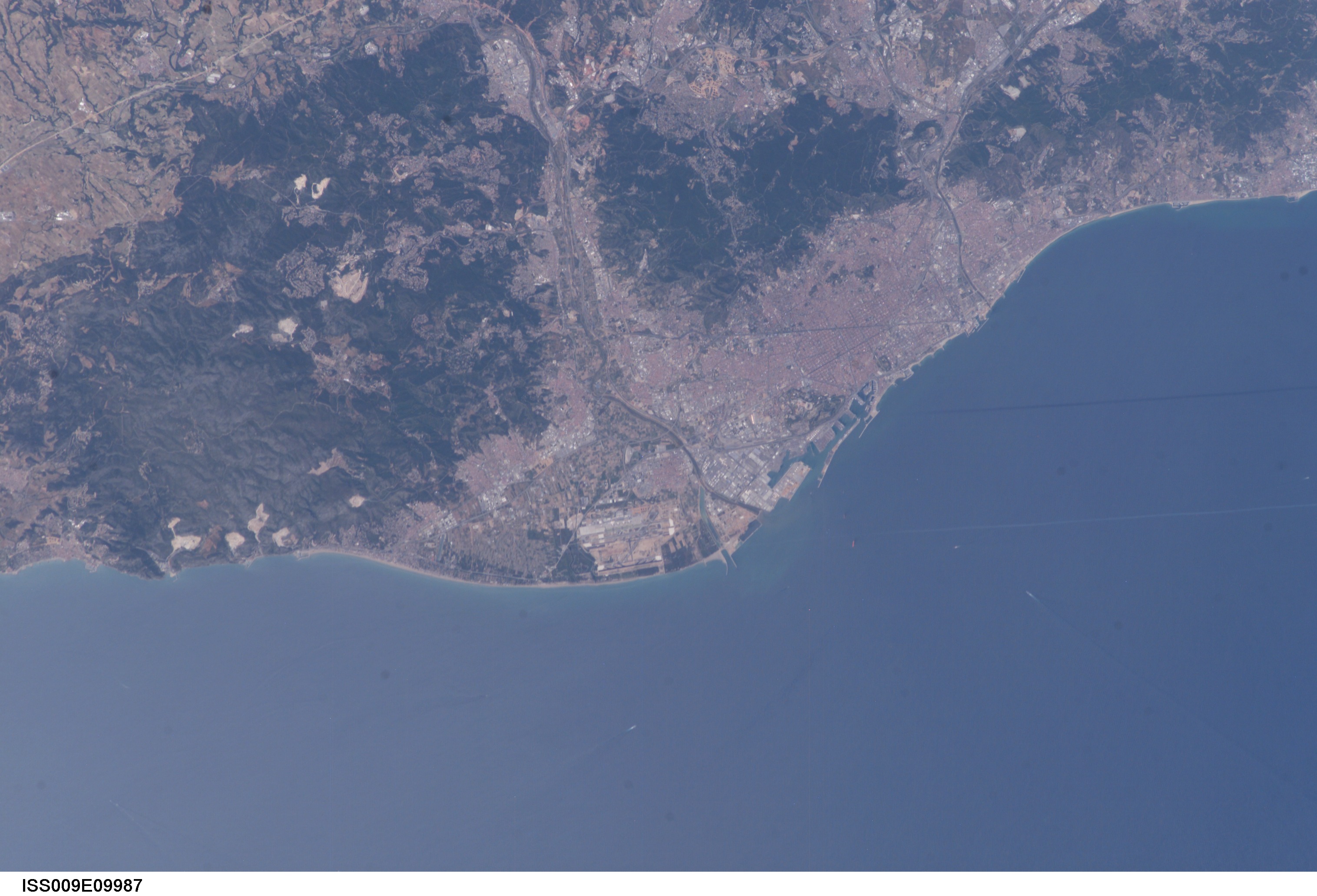
No GeoTIFF is available for this photo.Image Caption: Barcelona, Spain:
The roofs of Barcelona's buildings appear as a widespread pink swath on the Mediterranean coastal plain, between forested hills (dark green, top) and the sea. The Llobregat River enters the view top center, cuts through a canyon in the hills and historically constructed a broad, convex delta south of the forested hills. Channelization of the Llobregat River to control flooding has encouraged development of the delta for a variety of urban and agricultural land uses. Barcelona's airport is located in the central portion of the delta, while the western portion is used for intensive agriculture (light green areas).
Angular patterns on the coast represent the docks of Spain's largest port, on the east side of the delta. Central Barcelona lies between the docks and dark, forested Montjuic mountain (upper right).The Olympic village, built for the 1992 Olympic Games, occupies the waterfront east of the docks, with the old city just inland. The Besos River, also channelized to control flooding, defines the eastern part of the city. The population of the city proper, roughly between the rivers--a distance of 20 km--is ~1.5 million, but the entire metropolitan region reaches 4 million.
An interesting feature captured in this photograph is a white linear condensation trail silhouetted against the sea (right of image). The shadow of the contrail lies to the north (just offshore the port). Large vessels and their wakes appear as dots offshore just south of the condensation trail.
