< ISS040-E-11049 >
| NASA Photo ID | ISS040-E-11049 |
| Focal Length | 34mm |
| Date taken | 2014.06.13 |
| Time taken | 11:19:44 GMT |

Cloud masks available for this image:
Spacecraft nadir point: 34.5° S, 13.7° E
Photo center point:
Photo center point by machine learning:
Photo center point:
Photo center point by machine learning:
Nadir to Photo Center:
Spacecraft Altitude: 227 nautical miles (420km)Body: Earth
Country or Geographic Name: | |
Features: | |
| Features Found Using Machine Learning: | PAN- |
Cloud Cover Percentage: | 2 (1-10)% |
Sun Elevation Angle: | 32° |
Sun Azimuth: | 356° |
Camera: | NIKON D3S S/N: 2007931 |
Focal Length: | 34mm |
Camera Tilt: | |
Format: | |
Film Exposure: | |
| Additional Information | |
| Width | Height | Annotated | Cropped | Purpose | Links |
|---|---|---|---|---|---|
| 4256 pixels | 2832 pixels | No | No | Download Image | |
| 640 pixels | 426 pixels | No | No | Download Image |
Download Packaged File
Download a Google Earth KML for this Image
View photo footprint information
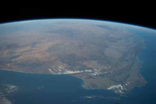
No GeoTIFF is available for this photo.Image Caption: ISS040-E-011049 (13 June 2014) --- One of the Expedition 40 crew members aboard the International Space Station photographed this panoramic scene of South Africa and Lesotho on June 13. In the easterly-looking view, Capetown can easily be delineated near bottom center. The country of Lesotho -- one of only three nations in the world which are landlocked and totally surrounded by a single country -- is near the lava plateau at top right.
