[Skip to Content]
Earth From Space
Earth from Space logo  11 Matches Search ResultsEarth from Space logo

Image: gray corner Image: gray corner
View Image Information
Image: Geographic Location
Image: gray corner Image: gray corner

Photo #: ISS001-702-110 Technical Info
All Available Images Lo-Resolution 90k
Features: AL HAWIZAH MARSH, TIGRIS
Geographic Region: IRAQ


Image: gray corner Image: gray corner
View Image Information
Image: Geographic Location
Image: gray corner Image: gray corner

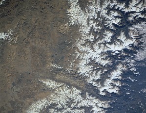
Photo #: ISS011-E-6717 Technical Info
All Available Images Lo-Resolution 308k
Features: URAL'SK, GLINT, URAL R., RIVER, BASIN, MARSH, SUNGLINT, SEA
Geographic Region: KAZAKHSTAN


Image: gray corner Image: gray corner
View Image Information
Image: Geographic Location
Image: gray corner Image: gray corner

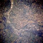
Photo #: ISS015-E-7725 Technical Info
All Available Images Lo-Resolution 228k
Features: DELTA, GULF, SUNGLINT, BAY, MARSH ISLAND, RIVER, ISLAND, EROSION, LAKE
Geographic Region: USA-LOUISIANA


Image: gray corner Image: gray corner
View Image Information
Image: Geographic Location
Image: gray corner Image: gray corner

Photo #: ISS015-E-8920 Technical Info
All Available Images Lo-Resolution 273k
Features: RIVER, ROADS, AGRICULTURE, MARSH, FLORIDA B., CAN., SUNGLINT, BAY
Geographic Region: USA-FLORIDA


Image: gray corner Image: gray corner
View Image Information
Image: Geographic Location
Image: gray corner Image: gray corner

Photo #: ISS024-E-9404 Technical Info
All Available Images Lo-Resolution 245k
Features: CHANNELS, DELTA, SUNGLINT, GULF, SHEEN, GLINT, SOUTH PASS, RIVER, EAST BAY, MISSISSIPPI R. DELTA, MARSH
Geographic Region: USA-LOUISIANA


Image: gray corner Image: gray corner
View Image Information
Image: Geographic Location
Image: gray corner Image: gray corner

Photo #: ISS031-E-30896 Technical Info
All Available Images Lo-Resolution 232k
Features: PIPELINE, PLATEAU, OIL WELLS, SEA, SOR KAYDAK MARSH
Geographic Region: KAZAKHSTAN


Image: gray corner Image: gray corner
View Image Information
Image: Geographic Location
Image: gray corner Image: gray corner

Photo #: ISS044-E-661 Technical Info
All Available Images Lo-Resolution 101k
Features: LACUSTRINE MARSHES, VILLAGES, ROADS, DRAINAGE, ISLAND, LAKE WALILUPE, LAKE, POND
Geographic Region: ZAMBIA


Image: gray corner Image: gray corner
View Image Information
Image: Geographic Location
Image: gray corner Image: gray corner

Photo #: STS055-152A-104 Technical Info
All Available Images Lo-Resolution 317k
Features: HIMALAYA RA, VALLEY, MARSHES, MOUNTAIN, FAULT, RIVER
Geographic Region: NEPAL


Image: gray corner Image: gray corner
View Image Information
Image: Geographic Location
Image: gray corner Image: gray corner

Photo #: STS058-88-53 Technical Info
All Available Images Lo-Resolution 435k
Features: MARSHAL, VALLEY, MISSOURI RIVER, RIVER, AGRICULTURE
Geographic Region: USA-KANSAS


Image: gray corner Image: gray corner
View Image Information
Image: Geographic Location
Image: gray corner Image: gray corner

Photo #: STS062-106-42 Technical Info
All Available Images Lo-Resolution 149k
Features: BURN SCARS, AGRICULTURE, L. HINDMARSH, PLAIN, HILL
Geographic Region: AUSTRALIA-V


Image: gray corner Image: gray corner
View Image Information
Image: Geographic Location
Image: gray corner Image: gray corner

Photo #: STS073-750-32 Technical Info
All Available Images Lo-Resolution 353k
Features: HIGHWAY, ESTUARY, PENINSULA, COAST, CHARLESTON, PLAIN, MARSH, RIVERS, ISLAND, URBAN AREA, RIVER
Geographic Region: USA-SOUTH CAROLINA


NASA
Home Page
JSC
Home Page
JSC Digital
Image Collection
Earth Science &
Remote Sensing
NASA meatball logo
This service is provided by the International Space Station program and the JSC Earth Science & Remote Sensing Unit, ARES Division, Exploration Integration Science Directorate.
ESRS logo