
Geographic Region: BOLIVIA
Feature: LAGO COIPASA
|
Geographic Region: BOLIVIA Feature: LAGO COIPASA |
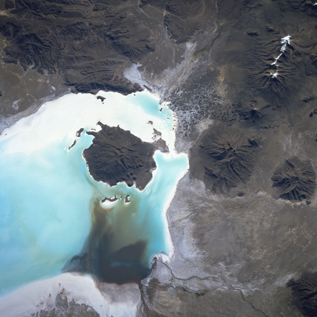 |
| STS51A-45-0055 Salar de Coipasa, Bolivia November 1984 Coipasa Volcano is located near the center of the image within Salar de Coipasa on the Altiplano (high plain) in southwestern Bolivia. In this 1984 image, standing water or brime is visible within Salar de Coipasa. Water is coming into the salar from the Laca Jahuira River, which is discernible at the bottom center of the image. The rainy season, normally from mid-November through March, can produce standing water in the salar up to 12 inches (30 cm) deep. The water is soon evaporated during the dry season. The dormant Coipasa Volcano is 16149 feet (4925 meters) high and stands nearly 4165 feet (1260 meters) above the salar floor. Other dormant and extinct volcanoes are visible in the Carabaya Mountains located northwest (right) of Salar de Coipasa. A structural depression, the salar was once part of a large glacier-fed lake named Minchin. The lake began to disappear about 15000 years ago and had disappeared completely about 10000 years ago, except for water remaining in depressions like Coipasa. (Also see image STS084-708-038 obtained in May 1997). |
| Images: | All Available Images Low-Resolution 312k |
|
| Mission: | STS51A |
|
| Roll - Frame: | 45 - 55 |
|
| Geographical Name: | BOLIVIA |
|
| Features: | LAGO COIPASA |
|
| Center Lat x Lon: | 19.3S x 68.3W |
|
| Film Exposure: | N | N=Normal exposure, U=Under exposed, O=Over exposed, F=out of Focus |
| Percentage of Cloud Cover-CLDP: | 0 |
|
| Camera:: | HB |
|
| Camera Tilt: | NV | LO=Low Oblique, HO=High Oblique, NV=Near Vertical |
| Camera Focal Length: | 250 |
|
| Nadir to Photo Center Direction: | The direction from the nadir to the center point, N=North, S=South, E=East, W=West |
|
| Stereo?: | N | Y=Yes there is an adjacent picture of the same area, N=No there isn't |
| Orbit Number: | 6 |
|
| Date: | 198411__ | YYYYMMDD |
| Time: | GMT HHMMSS |
|
| Nadir Lat: | N |
Latitude of suborbital point of spacecraft |
| Nadir Lon: | E |
Longitude of suborbital point of spacecraft |
| Sun Azimuth: | Clockwise angle in degrees from north to the sun measured at the nadir point |
|
| Space Craft Altitude: | nautical miles |
|
| Sun Elevation: | Angle in degrees between the horizon and the sun, measured at the nadir point |
|
| Land Views: | SALAR, VOLCANO |
|
| Water Views: | LAKE, RIVER |
|
| Atmosphere Views: | |
|
| Man Made Views: | |
|
| City Views: | |
|
Photo is not associated with any sequences | ||
| NASA Home Page |
JSC Home Page |
JSC Digital Image Collection |
Earth Science & Remote Sensing |
|
This service is provided by the International Space Station program and the JSC Earth Science & Remote Sensing Unit, ARES Division, Exploration Integration Science Directorate.

|