Geographic Region: PHILIPPINES
Feature: MT. PINATUBO,LAHARS,COAST
|
Geographic Region: PHILIPPINES Feature: MT. PINATUBO,LAHARS,COAST |
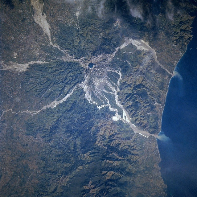 |
| STS080-706-045 Mount Pinatubo Volcano, Philippines November 1996 The ash and mud deposits of Mount Pinatubo Volcano are visible in this southeast-looking view. Located on western Luzon Island, Mount Pinatubo is one of a chain of composite volcanoes that constitute the Luzon Volcanic Arc. The Volcano erupted on June 15th, 1991, and again in July and August of 1991. Ash from the massive explosion reached 50000 feet (15000 meters) into the atmosphere. Locally, the ash reached a depth of 10 feet (3 meters) on the ground. Typhoon Yunya, which struck the island of Luzon about the same time as the eruption of Mount Pinatubo, triggered massive mudslides that killed about 550 people. The paths of these mudslides or lahars are discernible on this image. Clark Air Force Base is visible between two of the mudslides in the upper left portion of the image. The 18000 personnel and their dependents were evacuated from the base before the volcanic eruption, as were over 60000 people that were living on the slopes and valleys around the volcano, thus saving many thousands of lives. Minor eruptions continue at Mount Pinatubo. Annual tropical rains continue to cause ash and mudslides into the valleys surrounding the volcano. At the time this image was obtained, water filled the crater floor of the volcano. Sediment plumes are visible entering the South China Sea to the west of the volcano. |
| Images: | All Available Images Low-Resolution 381k |
|
| Mission: | STS080 |
|
| Roll - Frame: | 706 - 45 |
|
| Geographical Name: | PHILIPPINES |
|
| Features: | MT. PINATUBO,LAHARS,COAST |
|
| Center Lat x Lon: | 15.0N x 120.5E |
|
| Film Exposure: | N | N=Normal exposure, U=Under exposed, O=Over exposed, F=out of Focus |
| Percentage of Cloud Cover-CLDP: | 5 |
|
| Camera:: | HB |
|
| Camera Tilt: | 8 | LO=Low Oblique, HO=High Oblique, NV=Near Vertical |
| Camera Focal Length: | 250 |
|
| Nadir to Photo Center Direction: | S | The direction from the nadir to the center point, N=North, S=South, E=East, W=West |
| Stereo?: | Y | Y=Yes there is an adjacent picture of the same area, N=No there isn't |
| Orbit Number: | 67 |
|
| Date: | 19961124 | YYYYMMDD |
| Time: | 001826 | GMT HHMMSS |
| Nadir Lat: | 15.4N |
Latitude of suborbital point of spacecraft |
| Nadir Lon: | 120.7E |
Longitude of suborbital point of spacecraft |
| Sun Azimuth: | 124 | Clockwise angle in degrees from north to the sun measured at the nadir point |
| Space Craft Altitude: | 188 | nautical miles |
| Sun Elevation: | 28 | Angle in degrees between the horizon and the sun, measured at the nadir point |
| Land Views: | VOLCANO, HILL, EROSION, COAST |
|
| Water Views: | SEDIMENT |
|
| Atmosphere Views: | |
|
| Man Made Views: | |
|
| City Views: | |
|
Photo is not associated with any sequences | ||
| NASA Home Page |
JSC Home Page |
JSC Digital Image Collection |
Earth Science & Remote Sensing |
|
This service is provided by the International Space Station program and the JSC Earth Science & Remote Sensing Unit, ARES Division, Exploration Integration Science Directorate.

|