Geographic Region: KAZAKHSTAN
Feature: LAKE BALKHASH
|
Geographic Region: KAZAKHSTAN Feature: LAKE BALKHASH |
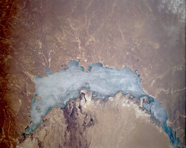 |
| STS059-L22-073 Lake Balkhash, Kazakhstan April 1994 Lake Balkhash, a large lake in eastern Kazakhstan, has no outlet in this land of vast deserts and steppe terrain. The brown and tan colors dominating the surrounding landscape indicate the harsh, waterless conditions of this environment. A sandbar effectively divides Lake Balkhash into a western half, which is fresh water, and an eastern half, which is saline. According to most accounts, the lake is slowly shrinking because of evaporation. Even though a fairly wide delta is visible along the southeastern end of the lake, the Ili River, which created the delta, does not have sufficient waterflow to exceed the rate of evaporation. The lake is 350 miles (565 kilometers) in length and about 45 miles (70 kilometers) at its maximum width, with an average depth is 20 feet (6 meters) and a maximum depth of 85 feet (25 meters). Lake Balkhash is usually frozen from November through March; however, in this April photograph, ice is still covering almost the entire surface of the lake. The small cities of Sary-Shagan and Balkhash are located along the western and northern shorelines, respectively, although not identifiable in this photograph. The white, highly reflective areas south of the lake are mineral deposits, mainly salts. Much of the landscape around the lake consists of sand; actually, areas of low sand dunes exist. |
| Images: | All Available Images Low-Resolution 101k |
|
| Mission: | STS059 |
|
| Roll - Frame: | L22 - 73 |
|
| Geographical Name: | KAZAKHSTAN |
|
| Features: | LAKE BALKHASH |
|
| Center Lat x Lon: | 46.5N x 75.0E |
|
| Film Exposure: | N | N=Normal exposure, U=Under exposed, O=Over exposed, F=out of Focus |
| Percentage of Cloud Cover-CLDP: | 0 |
|
| Camera:: | LH |
|
| Camera Tilt: | 42 | LO=Low Oblique, HO=High Oblique, NV=Near Vertical |
| Camera Focal Length: | 90 |
|
| Nadir to Photo Center Direction: | E | The direction from the nadir to the center point, N=North, S=South, E=East, W=West |
| Stereo?: | Y | Y=Yes there is an adjacent picture of the same area, N=No there isn't |
| Orbit Number: | 47 |
|
| Date: | 19940412 | YYYYMMDD |
| Time: | 073830 | GMT HHMMSS |
| Nadir Lat: | 46.0N |
Latitude of suborbital point of spacecraft |
| Nadir Lon: | 73.3E |
Longitude of suborbital point of spacecraft |
| Sun Azimuth: | 193 | Clockwise angle in degrees from north to the sun measured at the nadir point |
| Space Craft Altitude: | 118 | nautical miles |
| Sun Elevation: | 52 | Angle in degrees between the horizon and the sun, measured at the nadir point |
| Land Views: | DESERT, PLAIN, HILL |
|
| Water Views: | LAKE, RIVER, DELTA |
|
| Atmosphere Views: | |
|
| Man Made Views: | |
|
| City Views: | |
|
Photo is not associated with any sequences | ||
| NASA Home Page |
JSC Home Page |
JSC Digital Image Collection |
Earth Science & Remote Sensing |
|
This service is provided by the International Space Station program and the JSC Earth Science & Remote Sensing Unit, ARES Division, Exploration Integration Science Directorate.

|