Geographic Region: PORTUGAL
Feature: LISBON AREA
|
Geographic Region: PORTUGAL Feature: LISBON AREA |
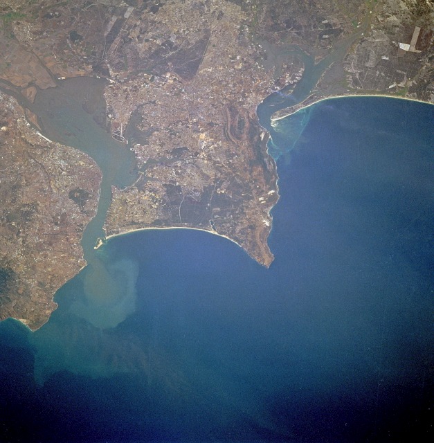 |
| STS047-085-095 Lisbon and Tagus River Estuary, Portugal September 1992 Lisbon, the capital of Portugal, is observable north of the Tagus River estuary in this low-oblique, northeast-looking photograph. The estuary of the Tagus River, the longest river in the Iberian Peninsula, is 12 miles (19 kilometers) long and is considered one of the best harbors in Europe. Lisbon is set on seven terraced hills and has a population of almost 900 000. Industries include textiles, chemicals, steel, oil and sugar refining, shipbuilding, soap and flour production, and tourism. A massive earthquake almost destroyed the city in 1755. Loss of life exceeded 50 000 people, and many buildings, some over 1000 years old, were destroyed. The city was rebuilt, and no subsequent major earthquakes have occurred. Visible south of the Tagus River estuary are the cites (west to east) of Almada, Barreiro, and Montijo; farther south are Setúbal Bay and the Sado River estuary. |
| Images: | All Available Images Low-Resolution 123k |
|
| Mission: | STS047 |
|
| Roll - Frame: | 85 - 95 |
|
| Geographical Name: | PORTUGAL |
|
| Features: | LISBON AREA |
|
| Center Lat x Lon: | 38.5N x 9W |
|
| Film Exposure: | N | N=Normal exposure, U=Under exposed, O=Over exposed, F=out of Focus |
| Percentage of Cloud Cover-CLDP: | 0 |
|
| Camera:: | HB |
|
| Camera Tilt: | 35 | LO=Low Oblique, HO=High Oblique, NV=Near Vertical |
| Camera Focal Length: | 250 |
|
| Nadir to Photo Center Direction: | E | The direction from the nadir to the center point, N=North, S=South, E=East, W=West |
| Stereo?: | Y | Y=Yes there is an adjacent picture of the same area, N=No there isn't |
| Orbit Number: | 14 |
|
| Date: | 19920913 | YYYYMMDD |
| Time: | 100831 | GMT HHMMSS |
| Nadir Lat: | 37.8N |
Latitude of suborbital point of spacecraft |
| Nadir Lon: | 10.8W |
Longitude of suborbital point of spacecraft |
| Sun Azimuth: | 125 | Clockwise angle in degrees from north to the sun measured at the nadir point |
| Space Craft Altitude: | 168 | nautical miles |
| Sun Elevation: | 43 | Angle in degrees between the horizon and the sun, measured at the nadir point |
| Land Views: | COAST |
|
| Water Views: | BAY, RIVER, SEDIMENT |
|
| Atmosphere Views: | |
|
| Man Made Views: | URBAN AREA, AIRPORT |
|
| City Views: | |
|
Photo is not associated with any sequences | ||
| NASA Home Page |
JSC Home Page |
JSC Digital Image Collection |
Earth Science & Remote Sensing |
|
This service is provided by the International Space Station program and the JSC Earth Science & Remote Sensing Unit, ARES Division, Exploration Integration Science Directorate.

|