
Geographic Region: KUWAIT
Feature: OIL FIELDS/PERSIAN GULF
|
Geographic Region: KUWAIT Feature: OIL FIELDS/PERSIAN GULF |
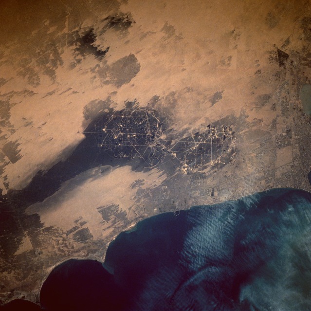 |
| STS044-75-27 Oil Well Fire Residue, Kuwait November 1991 This near-vertical photograph of southern Kuwait, taken nine months after the oil well fires of Desert Storm were ignited, shows the environmental devastation in the area immediately south of Kuwait City. The black and dark gray areas of the Alburoan Oil Field (large oil field in the center of the photograph) and the smaller Umm Gudair Oil Field to the west show the extent and pattern of environmental degradation caused by the smoke residue from the oil well fires. The interconnected roads and tiny, highly reflective, circular well heads within the Alburoan Field are easily discernible. The prevailing northwest wind direction is easily determined by the orientation of the oil residue stain on the desert and the alignment of the dual airport runways of Kuwait International Airport north of Alburoan and south of Kuwait City. Ground transportation features, such as roads, highways, and grid street patterns, are visible in Kuwait City along the northern edge of the photograph. |
| Images: | All Available Images Low-Resolution 116k |
|
| Mission: | STS044 |
|
| Roll - Frame: | 75 - 27 |
|
| Geographical Name: | KUWAIT |
|
| Features: | OIL FIELDS/PERSIAN GULF |
|
| Center Lat x Lon: | 29.0N x 48.0E |
|
| Film Exposure: | N | N=Normal exposure, U=Under exposed, O=Over exposed, F=out of Focus |
| Percentage of Cloud Cover-CLDP: | 0 |
|
| Camera:: | HB |
|
| Camera Tilt: | 9 | LO=Low Oblique, HO=High Oblique, NV=Near Vertical |
| Camera Focal Length: | 250 |
|
| Nadir to Photo Center Direction: | N | The direction from the nadir to the center point, N=North, S=South, E=East, W=West |
| Stereo?: | Y | Y=Yes there is an adjacent picture of the same area, N=No there isn't |
| Orbit Number: | 103 |
|
| Date: | 19911201 | YYYYMMDD |
| Time: | 114115 | GMT HHMMSS |
| Nadir Lat: | 28.5N |
Latitude of suborbital point of spacecraft |
| Nadir Lon: | 48.1E |
Longitude of suborbital point of spacecraft |
| Sun Azimuth: | 246 | Clockwise angle in degrees from north to the sun measured at the nadir point |
| Space Craft Altitude: | 198 | nautical miles |
| Sun Elevation: | -1 | Angle in degrees between the horizon and the sun, measured at the nadir point |
| Land Views: | DESERT, COAST, PLAIN |
|
| Water Views: | GULF |
|
| Atmosphere Views: | |
|
| Man Made Views: | URBAN AREA, DRILLING, AIRPORT |
|
| City Views: | KUWAIT CITY |
|
Associated Photos in Sequence:  Photo #: STS037-152-91 Photo #: STS037-152-91Description: KUWAIT OIL FIRES-APRIL, 1991 Sequence ID: 2A NO IMAGES - JUST INFORMATION Photo #: STS040-74-D Description: KUWAIT OIL FIRES-JUNE, 1991 Sequence ID: 2B  Photo #: STS044-75-27 ** Currently displayed photo ** Photo #: STS044-75-27 ** Currently displayed photo ** Description: KUWAIT, POST-FIRES--NOVEMBER, 1991 Sequence ID: 2C  Photo #: STS046-74-94 Photo #: STS046-74-94Description: KUWAIT, POST-FIRES--AUGUST, 1992 Sequence ID: 2D | ||
| NASA Home Page |
JSC Home Page |
JSC Digital Image Collection |
Earth Science & Remote Sensing |
|
This service is provided by the International Space Station program and the JSC Earth Science & Remote Sensing Unit, ARES Division, Exploration Integration Science Directorate.

|