Return to Earth From Space Home
Earth from Space logo Image Information Earth from Space logo

Display a Screen Layout for Printing

IMAGE: gray corner       IMAGE: gray corner
  Image: Geographic Location Direction Photo #: STS037-152-91 Date: Apr. 1991
Geographic Region: KUWAIT
Feature: FAYLAKA I.-KUWAIT FIRES

Ordering information for space photography
 
IMAGE: gray corner     IMAGE: gray corner

Image: gray corner     Image: gray corner
  View Low-Resolution Image  
  STS037-152-091 Oil Well Fires and Smoke, Kuwait April 1991
The effects of Iraq dictator Saddam Hussein's setting fire to the oil wells in Kuwait during February 1991 is graphically captured in this near-vertical photograph of the northwestern end of the Persian Gulf. The black smoke plumes of more than 700 individual oil well fires are being blown to the south. Kuwait City is located on the south side of Kuwait Bay, southwest of the Tigris-Euphrates Delta. Fortunately, the oil well fires were extinguished in much less time than had been originally predicted, and the environmental damage created by the fires and smoke was mostly confined to the immediate region around the northwestern Persian Gulf. (Refer to STS-046-074-094 for a photograph of the same area to see how quickly the desert is reclaiming the land in this region.)
 
Image: gray corner     Image: gray corner

Images: All Available Images Low-Resolution 65k
Mission: STS037  
Roll - Frame: 152 - 91
Geographical Name: KUWAIT  
Features: FAYLAKA I.-KUWAIT FIRES  
Center Lat x Lon: 29.5N x 48.5E
Film Exposure: N   N=Normal exposure, U=Under exposed, O=Over exposed, F=out of Focus
Percentage of Cloud Cover-CLDP: 0
 
Camera: LH
 
Camera Tilt: 18   LO=Low Oblique, HO=High Oblique, NV=Near Vertical
Camera Focal Length: 250  
 
Nadir to Photo Center Direction: NE   The direction from the nadir to the center point, N=North, S=South, E=East, W=West
Stereo?: Y   Y=Yes there is an adjacent picture of the same area, N=No there isn't
Orbit Number: 26  
 
Date: 19910407   YYYYMMDD
Time: 052403   GMT HHMMSS
Nadir Lat: 28.4N  
Latitude of suborbital point of spacecraft
Nadir Lon: 47.8E  
Longitude of suborbital point of spacecraft
Sun Azimuth: 104   Clockwise angle in degrees from north to the sun measured at the nadir point
Space Craft Altitude: 247   nautical miles
Sun Elevation: 36   Angle in degrees between the horizon and the sun, measured at the nadir point
Land Views: COAST, DESERT, PLAIN  
Water Views: BAY, GULF, DELTA, SEDIMENT, CHANNEL  
Atmosphere Views: SMOKE, PLUME  
Man Made Views: DRILLING, URBAN AREA, AIRPORT, POLLUTION  
City Views: KUWAIT CITY  
Associated Photos in Sequence:

IMAGEPhoto #: STS037-152-91 ** Currently displayed photo **
Description: KUWAIT OIL FIRES-APRIL, 1991
Sequence ID: 2A

NO IMAGES - JUST INFORMATION
Photo #: STS040-74-D
Description: KUWAIT OIL FIRES-JUNE, 1991
Sequence ID: 2B

IMAGE
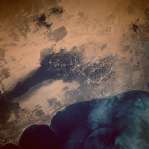
Photo #: STS044-75-27
Description: KUWAIT, POST-FIRES--NOVEMBER, 1991
Sequence ID: 2C

IMAGEPhoto #: STS046-74-94
Description: KUWAIT, POST-FIRES--AUGUST, 1992
Sequence ID: 2D


NASA
Home Page
JSC
Home Page
JSC Digital
Image Collection
Earth Science &
Remote Sensing

NASA meatball logo
This service is provided by the International Space Station program and the JSC Earth Science & Remote Sensing Unit, ARES Division, Exploration Integration Science Directorate.
ESRS logo