 Photo #: ISS050-E-28519 Date: Jan. 2017
Geographic Region: USA-IDAHO
Feature: PRIEST R., DEFORESTATION, WHITETAIL BUTTE, COLUMBIA MTS.

 Photo #: ISS050-E-28519 Date: Jan. 2017 Photo #: ISS050-E-28519 Date: Jan. 2017Geographic Region: USA-IDAHO Feature: PRIEST R., DEFORESTATION, WHITETAIL BUTTE, COLUMBIA MTS. |
 |
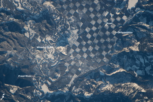
| Checkerboarding in Northern Idaho An astronaut aboard the International Space Station captured this distinctive checkerboard pattern along the Priest River in northern Idaho. It was taken just before sunset so southfacing mountain sides glow while the north faces are shadowed. The checkerboard of white squares is snow visible on deforested ground where trees have been removed for logging. These alternate with the dark squares of dense forest that obscure the snow from the astronaut's view. The checkerboard pattern resulted from an agreement in the early 1800s where alternate one-square-mile parcels of land were granted by the US Federal government to the Northern Pacific Railroad. These parcels were later sold to private companies and stripped for timber. This pattern is now seen as a method of maintaining the sustainability of forested tracts while still enabling logging companies to harvest trees. The forested squares are reserves now managed by the US Forest Service. Dense vegetation acts as a natural filtration system for nearby rivers, preserving water quality from degradation by soil eroded off deforested hillsides. The Priest River, winding through the scene from top to bottom, is bordered on both sides by forest to further protect the quality of its water. Prior to 1968, the river was used to transport logs for nearly a century. Its function changed when the river's entire main stem was added to the list of Wild and Scenic Rivers in 1968 to preserve its "...outstanding natural, cultural, and recreational values in a free-flowing condition for the enjoyment of present and future generations". Whitetail Butte next to the river (at image center) was historically used by the US Forest Service as a lookout point for forest fires. |
| Images: | All Available Images Low-Resolution 98k |
|
| Mission: | ISS050 |
|
| Roll - Frame: | E - 28519 |
|
| Geographical Name: | USA-IDAHO |
|
| Features: | PRIEST R., DEFORESTATION, WHITETAIL BUTTE, COLUMBIA MTS. |
|
| Center Lat x Lon: | 48.4N x 116.8W |
|
| Film Exposure: | N=Normal exposure, U=Under exposed, O=Over exposed, F=out of Focus |
|
| Percentage of Cloud Cover-CLDP: | 10 |
|
| Camera:: | N6 |
|
| Camera Tilt: | 17 | LO=Low Oblique, HO=High Oblique, NV=Near Vertical |
| Camera Focal Length: | 1150 |
|
| Nadir to Photo Center Direction: | W | The direction from the nadir to the center point, N=North, S=South, E=East, W=West |
| Stereo?: | Y=Yes there is an adjacent picture of the same area, N=No there isn't |
|
| Orbit Number: | |
|
| Date: | 20170104 | YYYYMMDD |
| Time: | 172818 | GMT HHMMSS |
| Nadir Lat: | 48.4N |
Latitude of suborbital point of spacecraft |
| Nadir Lon: | 115.7W |
Longitude of suborbital point of spacecraft |
| Sun Azimuth: | 147 | Clockwise angle in degrees from north to the sun measured at the nadir point |
| Space Craft Altitude: | 214 | nautical miles |
| Sun Elevation: | 13 | Angle in degrees between the horizon and the sun, measured at the nadir point |
| Land Views: | |
|
| Water Views: | |
|
| Atmosphere Views: | |
|
| Man Made Views: | |
|
| City Views: | |
|
Photo is not associated with any sequences | ||
| NASA Home Page |
JSC Home Page |
JSC Digital Image Collection |
Earth Science & Remote Sensing |
|
|