Geographic Region: NEPAL
Feature: HIMALAYA MOUNTAINS, GANGES RIVER, MOUNT EVEREST, TIBETAN PLATEAU
|
Geographic Region: NEPAL Feature: HIMALAYA MOUNTAINS, GANGES RIVER, MOUNT EVEREST, TIBETAN PLATEAU |
| Astronauts onboard the International Space Station (ISS) shot these photographs of the Himalayas, the Tibetan Plateau, and the Indo-Gangetic plain. The wide view above, taken in May 2012 by astronaut Don Pettit shows a dramatic 1000 kilometer (600 mile) stretch of the snow-capped peaks of the Himalayas. The Ganges/Ganga Plains occupy the foreground, and the numerous lakes and mountain glaciers of the Tibetan Plateau are visible beyond the mountains. The major rivers on the plains - the Ganges, Ghaghara, and Gandak - have transported vast amounts of sediment from the Himalayas over millions of years and deposited much of it in very large alluvial fans. Due to the oblique viewing angle from the ISS, the curve of Earth's limb defines the horizon visible from orbit. This photo view is close to the magnificent view that would have greeted Pettit's eyes that day because the lens he used (16 mm) is fairly close to the focal length of the human eye (about 25 mm). To the unaided eye, Chomolungma/Mount Everest, the highest peak on Earth (8,848.86 meters or 29,031.7 feet) is indistinguishable in this panoramic view. 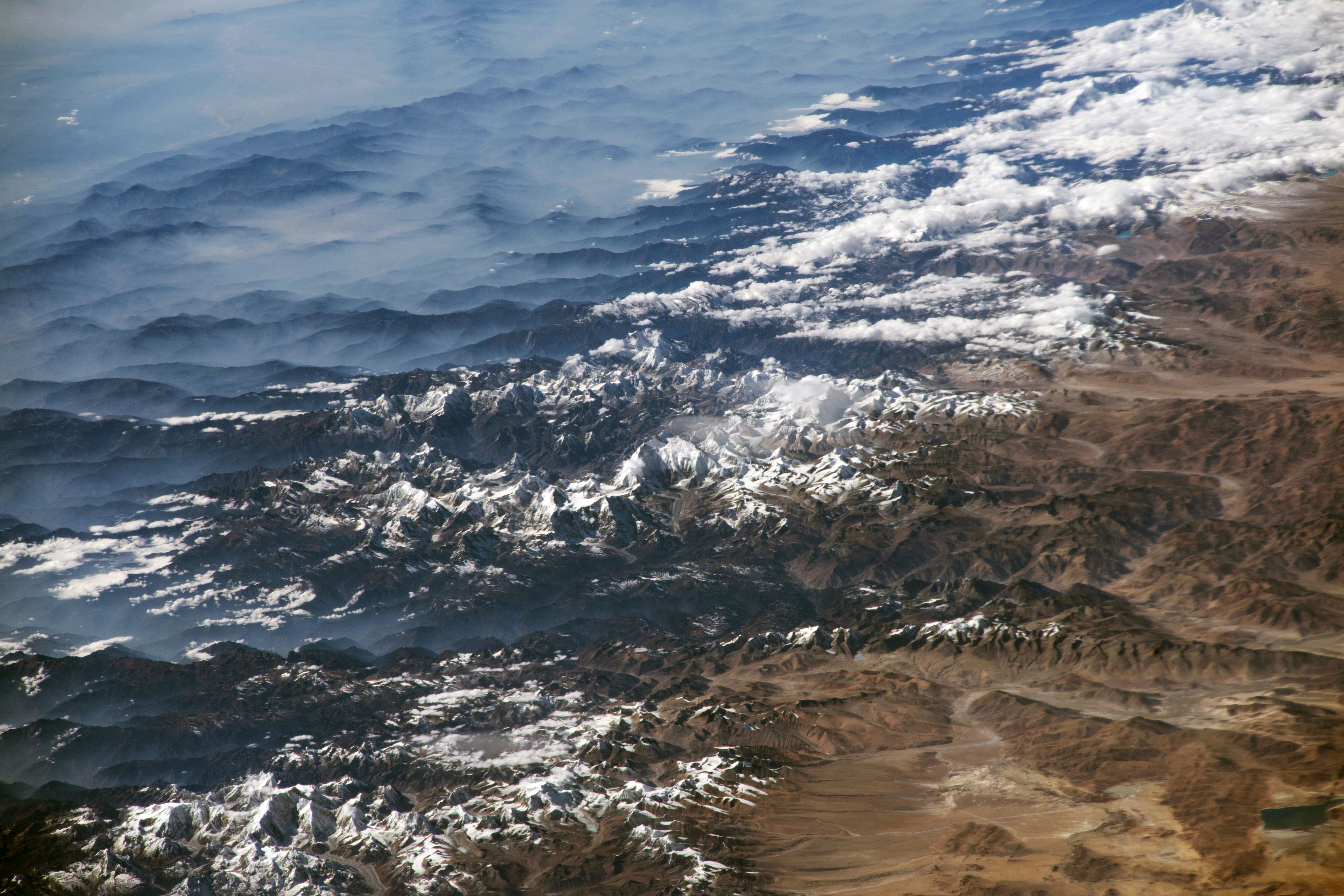 The second photo was shot by astronaut Randy "Komrade" Bresnik in December 2017 while looking southwest through a much longer lens (420 mm). It shows details from the part of the range that includes Mount Everest, which appears without its usual cloud cover. The extensive monsoon cloudiness that brings rain had not yet set in, though southerly winds blew up some of the major valleys onto the Tibetan Plateau, causing cloud streamers to rise. Two of the largest valleys that cut through the Himalaya Range lie just east and west of Chomolungma/Everest. Another reason for the clarity of the air on this day was that the usually hazy air pollution of the region was blown away by the winds. A gray mass of air pollution (upper left) still obscured some of the landscape detail on the plains. Learn more about astronaut photography in the Picturing Earth video series: part 1 Astronaut Photography in Focus; part 2 Window on the World; and part 3 Behind the Scenes. |
| Images: | All Available Images Low-Resolution 133k |
|
| Mission: | ISS031 |
|
| Roll - Frame: | E - 67020 |
|
| Geographical Name: | NEPAL |
|
| Features: | HIMALAYA MOUNTAINS, GANGES RIVER, MOUNT EVEREST, TIBETAN PLATEAU |
|
| Center Lat x Lon: | 28.5N x 81.0E |
|
| Film Exposure: | N=Normal exposure, U=Under exposed, O=Over exposed, F=out of Focus |
|
| Percentage of Cloud Cover-CLDP: | 25 |
|
| Camera:: | N2 |
|
| Camera Tilt: | 49 | LO=Low Oblique, HO=High Oblique, NV=Near Vertical |
| Camera Focal Length: | 16 |
|
| Nadir to Photo Center Direction: | E | The direction from the nadir to the center point, N=North, S=South, E=East, W=West |
| Stereo?: | Y=Yes there is an adjacent picture of the same area, N=No there isn't |
|
| Orbit Number: | |
|
| Date: | 20120523 | YYYYMMDD |
| Time: | 053954 | GMT HHMMSS |
| Nadir Lat: | 27.2N |
Latitude of suborbital point of spacecraft |
| Nadir Lon: | 77.0E |
Longitude of suborbital point of spacecraft |
| Sun Azimuth: | 109 | Clockwise angle in degrees from north to the sun measured at the nadir point |
| Space Craft Altitude: | 217 | nautical miles |
| Sun Elevation: | 73 | Angle in degrees between the horizon and the sun, measured at the nadir point |
| Land Views: | |
|
| Water Views: | |
|
| Atmosphere Views: | |
|
| Man Made Views: | |
|
| City Views: | |
|
Photo is not associated with any sequences | ||
| NASA Home Page |
JSC Home Page |
JSC Digital Image Collection |
Earth Science & Remote Sensing |
|
This service is provided by the International Space Station program and the JSC Earth Science & Remote Sensing Unit, ARES Division, Exploration Integration Science Directorate.

|