
Geographic Region: KAZAKHSTAN
Feature: SOR KAYDAK MARSH, OIL WELLS, PIPELINE
|
Geographic Region: KAZAKHSTAN Feature: SOR KAYDAK MARSH, OIL WELLS, PIPELINE |
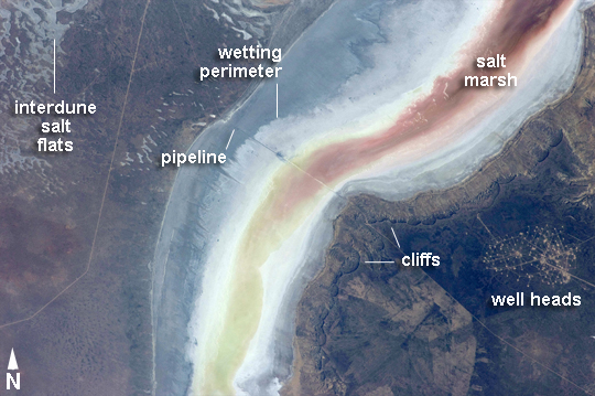 |
| Sor Kaydak, NE Caspian Sea, Kazakhstan Note: This caption refers to the image versions labeled "NASA's Earth Observatory web site". This striking image shows saline water of different colors in the Sor Kaydak, a salt marsh that leads into the northeast bulb of the Caspian Sea. The central 50 km of this 180 km-long depression is shown in this astronaut photograph. The Sor Kaydak depression is inundated on occasion by water from the Caspian Sea since it lies at the same elevation--that is, 29 m below global sea level--though separated from the Sea by a low bar of land that is 1-2 m high. The different colors of marsh water (brown to pink to light green, northeast to southwest) result from the interplay of water depth and resident organisms such as algae. Algae color varies depending on water temperature and salinity. The irregular gray areas at image top left are wet zones between low sand dunes. These interdune flats are whitened with salt derived by evaporation of Caspian Sea water (the sea is just outside the image top left). The jagged line following the colored water (crossing the center of the image top to bottom) is the limit of the wetting zone (or perimeter), an irregular zone influenced by wind and the depth of water in the marsh. Small cliffs can be seen marking the east margin of the depression that contains Sor Kaydak. Above the cliffs a plateau surface (~200 m above the salt marsh, ~160 m above global sea level) extends eastward for hundreds of km. Here the plateau is occupied by a dense pattern of well heads which appear as a geometric pattern of tan dots. By contrast, the west margin (image left) rises less than 10 m above the marsh altitude. The straight line visible at image center is a pipeline built across the salt marsh which takes oil to a terminal on the Caspian shore 100 km northwest of the area shown here. |
| Images: | Images: | NO IMAGES YET | |||
| Mission: | ISS031 |
||||
| Roll - Frame: | E - 30896 |
||||
| Geographical Name: | KAZAKHSTAN |
||||
| Features: | SOR KAYDAK MARSH, OIL WELLS, PIPELINE |
||||
| Center Lat x Lon: | 44.9N x 53.7E |
||||
| Film Exposure: | N=Normal exposure, U=Under exposed, O=Over exposed, F=out of Focus |
||||
| Percentage of Cloud Cover-CLDP: | 10 |
||||
| Camera:: | N2 |
||||
| Camera Tilt: | 45 | LO=Low Oblique, HO=High Oblique, NV=Near Vertical |
|||
| Camera Focal Length: | 180 |
||||
| Nadir to Photo Center Direction: | W | The direction from the nadir to the center point, N=North, S=South, E=East, W=West |
|||
| Stereo?: | Y=Yes there is an adjacent picture of the same area, N=No there isn't |
||||
| Orbit Number: | |
||||
| Date: | 20120511 | YYYYMMDD |
|||
| Time: | 050638 | GMT HHMMSS |
|||
| Nadir Lat: | 46.4N |
Latitude of suborbital point of spacecraft | |||
| Nadir Lon: | 56.9E |
Longitude of suborbital point of spacecraft | |||
| Sun Azimuth: | 112 | Clockwise angle in degrees from north to the sun measured at the nadir point |
|||
| Space Craft Altitude: | 214 | nautical miles |
|||
| Sun Elevation: | 43 | Angle in degrees between the horizon and the sun, measured at the nadir point |
|||
| Land Views: | PLATEAU |
||||
| Water Views: | SEA |
||||
| Atmosphere Views: | |
||||
| Man Made Views: | |
||||
| City Views: | |
||||
Photo is not associated with any sequences | |||||
| NASA Home Page |
JSC Home Page |
JSC Digital Image Collection |
Earth Science & Remote Sensing |
|
This service is provided by the International Space Station program and the JSC Earth Science & Remote Sensing Unit, ARES Division, Exploration Integration Science Directorate.

|