
Geographic Region: MEXICO
Feature: ENSENADA,DUST PLUMES
|
Geographic Region: MEXICO Feature: ENSENADA,DUST PLUMES |
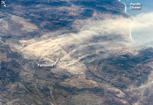 |
| ISS016-E-005526 (21 Oct. 2007) --- Dust plumes, Baja California, Mexico are featured in this image photographed by an Expedition 16 crewmember on the International Space Station. A major dust plume and several minor plumes were raised during the strong, dry Santa Ana winds of October 2007. The light brown dust was transported west out to the Pacific Ocean (top right). According to meteorologists, Santa Ana winds, because they are warm, dry and strong, reduce soil moisture and generate frequent dust storms such as this. On this occasion, the Santa Anas supported the outbreak of fires in southern California resulting in significant damage to homes in hilly, wooded country. Dust plumes are known to start from relatively small, dust-prone areas. Here the plumes rise from the Real del Castillo agricultural valley--25 miles long, and part of Mexico's wine-producing region--surrounded by rocky hills in northern Baja California. Specifically, the dust is rising from spreads of loose sediment known as alluvial fans. Small streams from the local hills carry sediment with every rainstorm and deposit it at the foot of small canyons on the east side of the valley. It is notable that the vegetated farmland itself--the small rectangular pattern on the valley floor--protects the soil from the wind and is not producing dust plumes. |
| Images: | All Available Images Low-Resolution 287k |
|
| Mission: | ISS016 |
|
| Roll - Frame: | E - 5526 |
|
| Geographical Name: | MEXICO |
|
| Features: | ENSENADA,DUST PLUMES |
|
| Center Lat x Lon: | 31.9N x 116.3W |
|
| Film Exposure: | N=Normal exposure, U=Under exposed, O=Over exposed, F=out of Focus |
|
| Percentage of Cloud Cover-CLDP: | 10 |
|
| Camera:: | E4 |
|
| Camera Tilt: | HO | LO=Low Oblique, HO=High Oblique, NV=Near Vertical |
| Camera Focal Length: | 280 |
|
| Nadir to Photo Center Direction: | SW | The direction from the nadir to the center point, N=North, S=South, E=East, W=West |
| Stereo?: | Y=Yes there is an adjacent picture of the same area, N=No there isn't |
|
| Orbit Number: | 3075 |
|
| Date: | 20071021 | YYYYMMDD |
| Time: | 192021 | GMT HHMMSS |
| Nadir Lat: | 37.1N |
Latitude of suborbital point of spacecraft |
| Nadir Lon: | 112.5W |
Longitude of suborbital point of spacecraft |
| Sun Azimuth: | 182 | Clockwise angle in degrees from north to the sun measured at the nadir point |
| Space Craft Altitude: | 182 | nautical miles |
| Sun Elevation: | 42 | Angle in degrees between the horizon and the sun, measured at the nadir point |
| Land Views: | PENINSULA, VALLEY |
|
| Water Views: | OCEAN, SEDIMENT |
|
| Atmosphere Views: | DUST, PLUME |
|
| Man Made Views: | |
|
| City Views: | |
|
Photo is not associated with any sequences | ||
| NASA Home Page |
JSC Home Page |
JSC Digital Image Collection |
Earth Science & Remote Sensing |
|
This service is provided by the International Space Station program and the JSC Earth Science & Remote Sensing Unit, ARES Division, Exploration Integration Science Directorate.

|