Geographic Region: BRAZIL
Feature: CANAL PERIGOSO, CAVIANA I.
|
Geographic Region: BRAZIL Feature: CANAL PERIGOSO, CAVIANA I. |
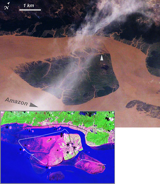 |
| Coastal Change, Amazon River Mouth Over a period of approximately four years a major island near the mouth of the Amazon River has been dramatically modified as the arms of the river have shifted. In the image above, an oblique image, captured by an astronaut with a handheld camera in January 2005 (base image), is contrasted with a false-color Landsat Enhanced Thematic Mapper plus (ETM+) image from 2000 (inset). In the Landsat inset, green indicates rainforest, pinks and mauves are low-growing, colonizing vegetation on tidally inundated areas, and the Amazon River is blue. The island is about 5 kilometers long and is located near 0.1deg N 49.7deg W). Between 2000 and 2005 the channel on the west side of the island has shifted to the northwest by eroding ~200 meters of the mainland shoreline and accreting (depositing) sediment on the west side of the island, broadly maintaining the width of the channel. White lines around the island in the inset image indicate the modern shorelines captured in the astronaut photograph. In the handheld photograph, the island shoreline of 2000 prominently demarcates older vegetated from new, not-yet-vegetated land surfaces (top arrow). By contrast, the northern channel (to the right of the island) has significantly widened, eroding almost 1 kilometer of the northern end of the island, as well as narrowing a smaller island downstream (lower right). A more important but subtler effect has been the accumulation of sediment on the upstream (left-hand) two-thirds of the island, accompanied by the establishment of permanent vegetation (dark green). Vegetation appears to anchor small streams in place, but discharge in major arms of the Amazon overcomes the cohesive power of vegetation so that large channels can be comparatively mobile. Other islands in the Amazon mouth are also known to have moved by hundreds of meters per year due to the processes of erosion and deposition. |
| Images: | All Available Images Low-Resolution 337k |
|
| Mission: | ISS010 |
|
| Roll - Frame: | E - 13029 |
|
| Geographical Name: | BRAZIL |
|
| Features: | CANAL PERIGOSO, CAVIANA I. |
|
| Center Lat x Lon: | .1N x 49.7W |
|
| Film Exposure: | N=Normal exposure, U=Under exposed, O=Over exposed, F=out of Focus |
|
| Percentage of Cloud Cover-CLDP: | 50 |
|
| Camera:: | E4 |
|
| Camera Tilt: | 43 | LO=Low Oblique, HO=High Oblique, NV=Near Vertical |
| Camera Focal Length: | 400 |
|
| Nadir to Photo Center Direction: | W | The direction from the nadir to the center point, N=North, S=South, E=East, W=West |
| Stereo?: | Y=Yes there is an adjacent picture of the same area, N=No there isn't |
|
| Orbit Number: | 3139 |
|
| Date: | 20050113 | YYYYMMDD |
| Time: | 173526 | GMT HHMMSS |
| Nadir Lat: | 0.2S |
Latitude of suborbital point of spacecraft |
| Nadir Lon: | 46.7W |
Longitude of suborbital point of spacecraft |
| Sun Azimuth: | 236 | Clockwise angle in degrees from north to the sun measured at the nadir point |
| Space Craft Altitude: | 191 | nautical miles |
| Sun Elevation: | 50 | Angle in degrees between the horizon and the sun, measured at the nadir point |
| Land Views: | EROSION, ISLAND |
|
| Water Views: | CHANNEL, RIVER, SEDIMENT |
|
| Atmosphere Views: | |
|
| Man Made Views: | |
|
| City Views: | MOBILE |
|
Photo is not associated with any sequences | ||
| NASA Home Page |
JSC Home Page |
JSC Digital Image Collection |
Earth Science & Remote Sensing |
|
This service is provided by the International Space Station program and the JSC Earth Science & Remote Sensing Unit, ARES Division, Exploration Integration Science Directorate.

|