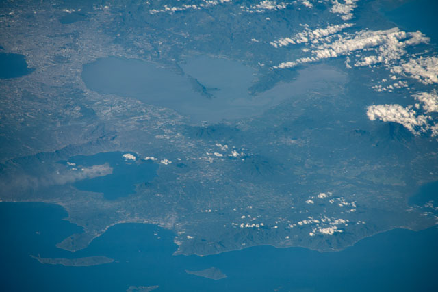
ISS061-E-138226
| NASA Photo ID | ISS061-E-138226 |
| Focal Length | 500mm |
| Date taken | 2020.01.22 |
| Time taken | 07:56:42 GMT |

Spacecraft nadir point: 5.6° N, 119.2° E
Photo center point: 14.1° N, 121.2° E
Photo center point by machine learning:
Photo center point: 14.1° N, 121.2° E
Photo center point by machine learning:
Nadir to Photo Center: North
Spacecraft Altitude: 227 nautical miles (420km)
Country or Geographic Name: | PHILIPPINES |
Features: | TAAL VOLCANO, SMOKE PLUME, ERUPTION, MANILA, CALAMBA |
| Features Found Using Machine Learning: | |
Cloud Cover Percentage: | 25 (11-25)% |
Sun Elevation Angle: | 30° |
Sun Azimuth: | 243° |
Camera: | Nikon D5 Electronic Still Camera |
Focal Length: | 500mm |
Camera Tilt: | High Oblique |
Format: | 5568E: 5568 x 3712 pixel CMOS sensor, 35.9 x 23.9 mm, total pixels: 21.33 million, Nikon FX format |
Film Exposure: | |
| Additional Information | |
| Width | Height | Annotated | Cropped | Purpose | Links |
|---|---|---|---|---|---|
| 5568 pixels | 3712 pixels | No | No | Download Image | |
| 640 pixels | 427 pixels | No | No | Download Image |
Download Packaged File
Download a Google Earth KML for this Image
View photo footprint information
Download a GeoTIFF for this photo
Georeferenced by human interaction - exported 2020-01-23-224659-UTCGeoreferenced by human interaction - exported 2020-06-18-075354-UTC
Georeferenced by human interaction - exported 2020-06-18-075843-UTC
Georeferenced by human interaction - exported 2020-06-18-205039-UTC
Georeferenced by human interaction - exported 2020-06-18-205454-UTC
Georeferenced by human interaction - exported 2020-06-18-205928-UTC
Georeferenced by human interaction - exported 2020-06-18-210243-UTC
Georeferenced by human interaction - exported 2020-06-18-210656-UTC
Georeferenced by human interaction - exported 2020-06-18-211046-UTC
Georeferenced by human interaction - exported 2020-06-18-215017-UTC
Georeferenced by human interaction - exported 2020-06-18-220247-UTC
Georeferenced by human interaction - exported 2020-06-18-221834-UTC
Georeferenced by human interaction - exported 2020-06-18-222208-UTC
Georeferenced by human interaction - exported 2020-06-18-223959-UTC
Georeferenced by human interaction - exported 2020-06-29-165935-UTC
Georeferenced by human interaction - exported 2020-06-29-185635-UTC
An explanation of the georeference file(s) above
Image Caption: none
