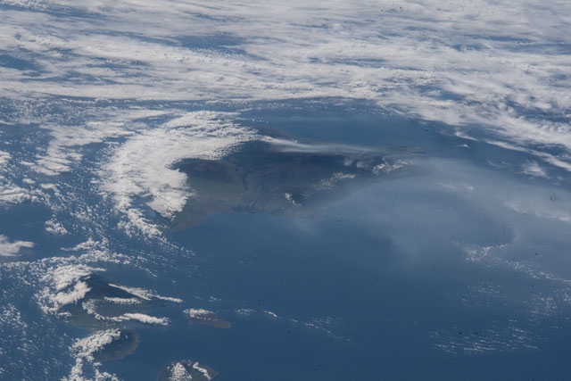
ISS055-E-70278
| NASA Photo ID | ISS055-E-70278 |
| Focal Length | 155mm |
| Date taken | 2018.05.12 |
| Time taken | 19:05:36 GMT |

Spacecraft nadir point: 24.9° N, 163.2° W
Photo center point: 19.7° N, 155.8° W
Photo center point by machine learning:
Photo center point: 19.7° N, 155.8° W
Photo center point by machine learning:
Nadir to Photo Center: Southeast
Spacecraft Altitude: 216 nautical miles (400km)
Country or Geographic Name: | USA-HAWAII |
Features: | BIG ISLAND, MAUI, ERUPTION |
| Features Found Using Machine Learning: | |
Cloud Cover Percentage: | 75 (51-75)% |
Sun Elevation Angle: | 38° |
Sun Azimuth: | 86° |
Camera: | Nikon D5 Electronic Still Camera |
Focal Length: | 155mm |
Camera Tilt: | High Oblique |
Format: | 5568E: 5568 x 3712 pixel CMOS sensor, 35.9 x 23.9 mm, total pixels: 21.33 million, Nikon FX format |
Film Exposure: | |
| Additional Information | |
| Width | Height | Annotated | Cropped | Purpose | Links |
|---|---|---|---|---|---|
| 5568 pixels | 3712 pixels | No | No | Download Image | |
| 640 pixels | 427 pixels | No | No | Download Image |
Download Packaged File
Download a Google Earth KML for this Image
View photo footprint information
Download a GeoTIFF for this photo
Georeferenced by human interaction - exported 2018-05-15-225154-UTCAn explanation of the georeference file(s) above
Image Caption: none
