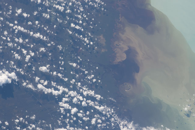
ISS053-E-11031
| NASA Photo ID | ISS053-E-11031 |
| Focal Length | 400mm |
| Date taken | 2017.09.12 |
| Time taken | 13:49:02 GMT |

Spacecraft nadir point: 27.5° N, 80.5° W
Photo center point: 25.7° N, 81.3° W
Photo center point by machine learning:
Photo center point: 25.7° N, 81.3° W
Photo center point by machine learning:
Nadir to Photo Center: South
Spacecraft Altitude: 217 nautical miles (402km)
Country or Geographic Name: | USA-FLORIDA |
Features: | PAVILION KEY, HUSTON COVE, HUSTON R., CHEVELIER B., SEDIMENT OUTWASH, FIRST B. |
| Features Found Using Machine Learning: | |
Cloud Cover Percentage: | 25 (11-25)% |
Sun Elevation Angle: | 35° |
Sun Azimuth: | 106° |
Camera: | Nikon D4 Electronic Still Camera |
Focal Length: | 400mm |
Camera Tilt: | 29 degrees |
Format: | 4928E: 4928 x 3280 pixel CMOS sensor, 36.0mm x 23.9mm, total pixels: 16.6 million, Nikon FX format |
Film Exposure: | |
| Additional Information | |
| Width | Height | Annotated | Cropped | Purpose | Links |
|---|---|---|---|---|---|
| 4928 pixels | 3280 pixels | No | No | Download Image | |
| 640 pixels | 426 pixels | No | No | Download Image |
Download Packaged File
Download a Google Earth KML for this Image
View photo footprint information
Download a GeoTIFF for this photo
Georeferenced by human interaction - exported 2017-09-13-195708-UTCAn explanation of the georeference file(s) above
Image Caption: none
