ISS040-E-478
| NASA Photo ID | ISS040-E-478 |
| Focal Length | 80mm |
| Date taken | 2014.05.17 |
| Time taken | 16:42:25 GMT |

Spacecraft nadir point: 20.2° N, 72.0° W
Photo center point: 21.5° N, 72.0° W
Photo center point by machine learning:
Photo center point: 21.5° N, 72.0° W
Photo center point by machine learning:
Nadir to Photo Center: North
Spacecraft Altitude: 224 nautical miles (415km)
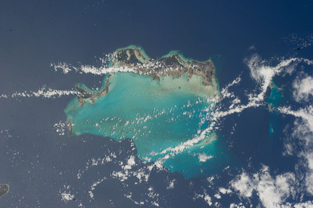
Country or Geographic Name: | TURKS AND CAICOS IS. |
Features: | CAICOS BANK, PROVIDENCIALS, NORTH CAICOS, GRAND CAICOS, EAST CAICOS |
| Features Found Using Machine Learning: | |
Cloud Cover Percentage: | 25 (11-25)% |
Sun Elevation Angle: | 89° |
Sun Azimuth: | 145° |
Camera: | Nikon D3S Electronic Still Camera |
Focal Length: | 80mm |
Camera Tilt: | 19 degrees |
Format: | 4256E: 4256 x 2832 pixel CMOS sensor, 36.0mm x 23.9mm, total pixels: 12.87 million, Nikon FX format |
Film Exposure: | |
| Additional Information | |
| Width | Height | Annotated | Cropped | Purpose | Links |
|---|---|---|---|---|---|
| 4256 pixels | 2832 pixels | No | No | Download Image | |
| 640 pixels | 426 pixels | No | No | Download Image |
Download Packaged File
Download a Google Earth KML for this Image
View photo footprint information
Download a GeoTIFF for this photo
Image Caption: ISS040-E-000478 (17 May 2014) --- One of the Expedition 40 crew members aboard the International Space Station used an 80mm lens on a digital still camera to photograph this image of the Turks and Caicos Islands. Those pictured include components of the Caicos -- Providenciales, North Caicos, Grand Caicos and East Caicos. The Turks Islands, including Grand Turk (under clouds), are on the right.
