[Skip to Content]
Earth From Space
Earth from Space logo  10 Matches Search ResultsEarth from Space logo

Image: gray corner Image: gray corner
View Image Information
Image: Geographic Location
Image: gray corner Image: gray corner

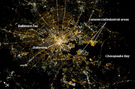
Photo #: ISS033-E-14186 Technical Info
All Available Images Lo-Resolution 241k
Features: BAY, COAST, MIDDLE RIVER, BALTIMORE METRO AREA AT NIGHT, PORT, BALTIMORE, CHESAPEAKE BAY
Geographic Region: USA-MARYLAND


Image: gray corner Image: gray corner
View Image Information
Image: Geographic Location
Image: gray corner Image: gray corner

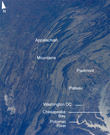
Photo #: ISS033-E-22378 Technical Info
All Available Images Lo-Resolution 521k
Features: ISS, SUNGLINT, RANGE, CHESAPEAKE BAY, PLATEAU, RIVER, WASHINGTON D.C., LAKE ERIE, BAY, VALLEY, APPALACHIAN MTS., GLINT, MOUNTAIN
Geographic Region: USA-PENNSYLVANIA


Image: gray corner Image: gray corner
View Image Information
Image: Geographic Location
Image: gray corner Image: gray corner

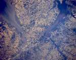
Photo #: STS040-152-129 Technical Info
All Available Images Lo-Resolution 355k
Features: SEDIMENT, DELAWARE BAYS, HIGHWAY, CANAL, PLAIN, BAY, CHESAPEAKE, RIVER, AGRICULTURE
Geographic Region: USA-MARYLAND


Image: gray corner Image: gray corner
View Image Information
Image: Geographic Location
Image: gray corner Image: gray corner

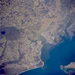
Photo #: STS062-89-1 Technical Info
All Available Images Lo-Resolution 353k
Features: SEDIMENT, NORFOLK, BAY, NEWPORT NEWS, SWAMP, RIVER, CHESAPEAKE BAY, URBAN AREA, COAST, PORTSMOUTH
Geographic Region: USA-VIRGINIA


Image: gray corner Image: gray corner
View Image Information
Image: Geographic Location
Image: gray corner Image: gray corner

Photo #: STS068-264-6 Technical Info
All Available Images Lo-Resolution 397k
Features: SEDIMENT, DELAWARE BAY, PLAIN, BAY, CHESAPEAKE, RIVER, COAST, URBAN AREA, SUNGLINT
Geographic Region: USA-MARYLAND


Image: gray corner Image: gray corner
View Image Information
Image: Geographic Location
Image: gray corner Image: gray corner

Photo #: STS073-741-62 Technical Info
All Available Images Lo-Resolution 361k
Features: BAY, AGR, AIRPORT, FOREST, CHESAPEAKE B., URBAN AREA, CITIES, ANNAPOLIS, ESTUARY
Geographic Region: USA-MARYLAND


Image: gray corner Image: gray corner
View Image Information
Image: Geographic Location
Image: gray corner Image: gray corner

Photo #: STS073-741-63 Technical Info
All Available Images Lo-Resolution 393k
Features: URBAN AREA, AGRICULTURE, BAY, FOREST, CHESAPEAKE BAY, ESTUARY, BALTIMORE
Geographic Region: USA-MARYLAND


Image: gray corner Image: gray corner
View Image Information
Image: Geographic Location
Image: gray corner Image: gray corner

Photo #: STS073-741-64 Technical Info
All Available Images Lo-Resolution 400k
Features: AGRICULTURE, CITY, BAY, PLAIN, ESTUARY, CHESAPEAKE BAY, AGR.
Geographic Region: USA-MARYLAND


Image: gray corner Image: gray corner
View Image Information
Image: Geographic Location
Image: gray corner Image: gray corner

Photo #: STS079-783-26 Technical Info
All Available Images Lo-Resolution 381k
Features: BALTIMORE, CHESAPEAKE B., AIRPORT, BAY, COAST, HIGHWAY
Geographic Region: USA-MARYLAND


Image: gray corner Image: gray corner
View Image Information
Image: Geographic Location
Image: gray corner Image: gray corner

Photo #: STS090-712-43 Technical Info
All Available Images Lo-Resolution 382k
Features: BALTIMORE, CHESAPEAKE BAY, BAY, PLAIN, URBAN AREA, LAKE
Geographic Region: USA-MARYLAND


NASA Human
Space Flight
NASA
Home Page
JSC
Home Page
NASA
Image eXchange
JSC Digital
Image Collection
Earth Science &
Remote Sensing
This service is provided by the International Space Station program and the JSC Earth Science & Remote Sensing Unit, ARES Division, Exploration Integration Science Directorate.
NASA meatball logo
ESRS logo