Geographic Region: CHINA
Feature: PRATAS ISLAND
|
Geographic Region: CHINA Feature: PRATAS ISLAND |
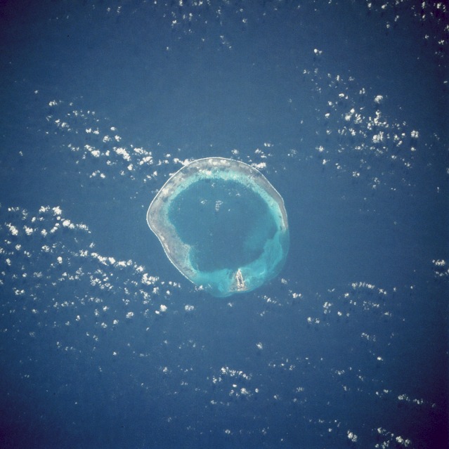 |
| STS61C-46-0010 Pratas (Dongsha) Island, South China Sea January 1986 Pratas Island, its lagoon, and its horseshoe-shaped coral reef are the centerpiece in this southeast-looking, low-oblique photograph. Named Dongsha Island (East Sand Island) by the Chinese, Pratas is approximately 200 miles (322 kilometers) southeast of Hong Kong in the northern South China Sea. The island and its reef are the remains of coral skeletons on a submerged sea terrace now 984 feet (300 meters) below the sea surface. The island is a sanctuary for many tropical birds. The phosphorous-rich lime soils of the island mix with the abundant bird guano deposits to make excellent fertilizer that is transported by the Chinese to the mainland for agricultural use. |
| Images: | All Available Images Low-Resolution 92k |
|
| Mission: | STS61C |
|
| Roll - Frame: | 46 - 10 |
|
| Geographical Name: | CHINA |
|
| Features: | PRATAS ISLAND |
|
| Center Lat x Lon: | 20.5N x 117.0E |
|
| Film Exposure: | N | N=Normal exposure, U=Under exposed, O=Over exposed, F=out of Focus |
| Percentage of Cloud Cover-CLDP: | 20 |
|
| Camera:: | HB |
|
| Camera Tilt: | 17 | LO=Low Oblique, HO=High Oblique, NV=Near Vertical |
| Camera Focal Length: | 250 |
|
| Nadir to Photo Center Direction: | NE | The direction from the nadir to the center point, N=North, S=South, E=East, W=West |
| Stereo?: | Y | Y=Yes there is an adjacent picture of the same area, N=No there isn't |
| Orbit Number: | 10 |
|
| Date: | 19860113 | YYYYMMDD |
| Time: | 014908 | GMT HHMMSS |
| Nadir Lat: | 20.1N |
Latitude of suborbital point of spacecraft |
| Nadir Lon: | 116.2E |
Longitude of suborbital point of spacecraft |
| Sun Azimuth: | 135 | Clockwise angle in degrees from north to the sun measured at the nadir point |
| Space Craft Altitude: | 181 | nautical miles |
| Sun Elevation: | 33 | Angle in degrees between the horizon and the sun, measured at the nadir point |
| Land Views: | ISLAND |
|
| Water Views: | LAGOON, SEA, REEF |
|
| Atmosphere Views: | |
|
| Man Made Views: | MINING |
|
| City Views: | |
|
Photo is not associated with any sequences | ||
| NASA Home Page |
JSC Home Page |
JSC Digital Image Collection |
Earth Science & Remote Sensing |
|
This service is provided by the International Space Station program and the JSC Earth Science & Remote Sensing Unit, ARES Division, Exploration Integration Science Directorate.

|