
Geographic Region: NIGERIA
Feature: NIGER R. DELTA, COAST
|
Geographic Region: NIGERIA Feature: NIGER R. DELTA, COAST |
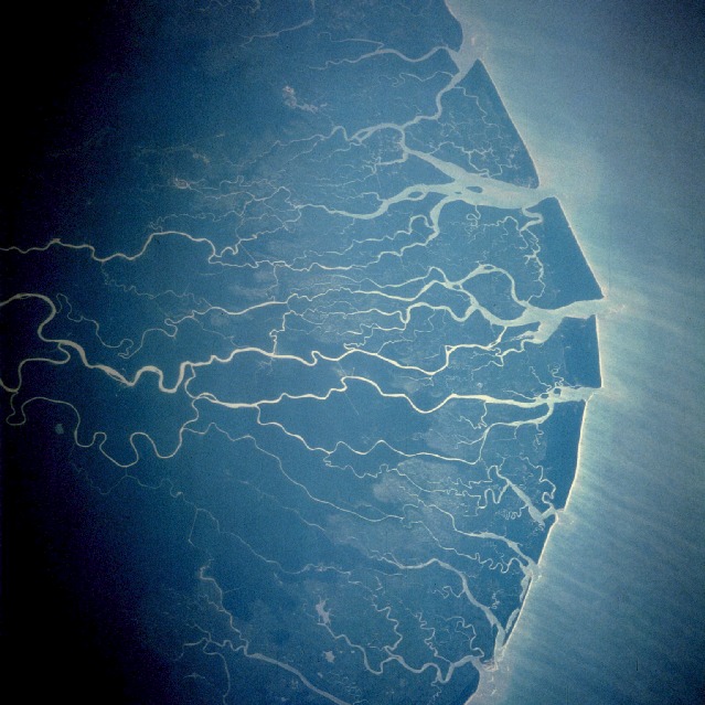 |
| STS61C-42-72 Niger River Delta January 1986 This near-vertical photograph shows the fan-shaped Niger River Delta, the largest delta in Africa, which covers 14 000 square miles (36 260 square kilometers). Rising in the highlands of the Fouta Djallon Plateau in western Guinea 150 miles (240 kilometers) from the Atlantic Ocean, Africa's third longest river [2600 miles (4185 kilometers)] flows northeast into Mali. In central Mali, the Niger forms a vast inland delta, a maze of channels and shallow lakes. Just below Timbuktu, the Niger bends, flowing first east, then southeast from Mali through the Republic of Niger, and finally into Nigeria. At Lokoja in central Nigeria, the Niger is joined by its chief tributary, the Benue. The Niger then proceeds south 250 miles (400 kilometers), becoming a great fan-shaped delta before emptying into the Gulf of Guinea. The delta is characterized by numerous lagoons and mangrove swamps that extend 60 miles (95 kilometers) inland from the coast in some areas. A number of channels are clogged with sandbars; however, others are navigable by oceangoing vessels, thereby making the Niger River, the "Nile of west Africa," an important avenue of commerce for this part of Africa. |
| Images: | All Available Images Low-Resolution 122k |
|
| Mission: | STS61C |
|
| Roll - Frame: | 42 - 72 |
|
| Geographical Name: | NIGERIA |
|
| Features: | NIGER R. DELTA, COAST |
|
| Center Lat x Lon: | 4.5N x 6.0E |
|
| Film Exposure: | N | N=Normal exposure, U=Under exposed, O=Over exposed, F=out of Focus |
| Percentage of Cloud Cover-CLDP: | 0 |
|
| Camera:: | HB |
|
| Camera Tilt: | 34 | LO=Low Oblique, HO=High Oblique, NV=Near Vertical |
| Camera Focal Length: | 250 |
|
| Nadir to Photo Center Direction: | SE | The direction from the nadir to the center point, N=North, S=South, E=East, W=West |
| Stereo?: | Y | Y=Yes there is an adjacent picture of the same area, N=No there isn't |
| Orbit Number: | 47 |
|
| Date: | 19860115 | YYYYMMDD |
| Time: | 100633 | GMT HHMMSS |
| Nadir Lat: | 5.6N |
Latitude of suborbital point of spacecraft |
| Nadir Lon: | 4.3E |
Longitude of suborbital point of spacecraft |
| Sun Azimuth: | 136 | Clockwise angle in degrees from north to the sun measured at the nadir point |
| Space Craft Altitude: | 180 | nautical miles |
| Sun Elevation: | 52 | Angle in degrees between the horizon and the sun, measured at the nadir point |
| Land Views: | COAST, PLAIN, FOREST |
|
| Water Views: | RIVER, DELTA, LAGOON, CHANNEL |
|
| Atmosphere Views: | |
|
| Man Made Views: | |
|
| City Views: | |
|
Photo is not associated with any sequences | ||
| NASA Home Page |
JSC Home Page |
JSC Digital Image Collection |
Earth Science & Remote Sensing |
|
This service is provided by the International Space Station program and the JSC Earth Science & Remote Sensing Unit, ARES Division, Exploration Integration Science Directorate.

|