Geographic Region: BRAZIL
Feature: COAST,R. PARAIBA DO SUL
|
Geographic Region: BRAZIL Feature: COAST,R. PARAIBA DO SUL |
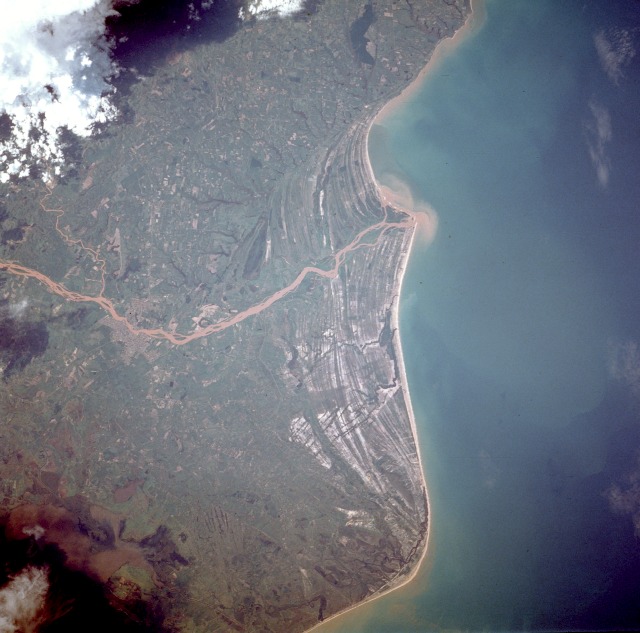 |
| STS61C-40-0096 Rio Paraiba do Sul, Brazil January 1986 The sediment-laden Rio Paraiba do Sul is observed as it flows eastward and empties into the Atlantic Ocean. The delta and floodplain created by this river provide ample pastureland for raising cattle on the open savanna along the coast. The faint outline of Campos, a city of nearly 500 000 people, can be seen along the Rio Paraiba do Sul 35 miles (55 kilometers) from the river's mouth. Campos is the hub of both the cattle industry and an agricultural region known for its sugar production. In colonial times, Campos was one of the major gateways to the interior of Brazil. One of the most striking features in this nearly vertical photograph is the numerous striated beach terraces that generally parallel the coastline. The curving coastline near the southern edge of the photograph is Cabo de Sao Tome; the murky, grayish feature in the southwest corner of the photograph is part of Lake Feia. |
| Images: | All Available Images Low-Resolution 106k |
|
| Mission: | STS61C |
|
| Roll - Frame: | 40 - 96 |
|
| Geographical Name: | BRAZIL |
|
| Features: | COAST,R. PARAIBA DO SUL |
|
| Center Lat x Lon: | 21.5S x 41W |
|
| Film Exposure: | N | N=Normal exposure, U=Under exposed, O=Over exposed, F=out of Focus |
| Percentage of Cloud Cover-CLDP: | 15 |
|
| Camera:: | HB |
|
| Camera Tilt: | 24 | LO=Low Oblique, HO=High Oblique, NV=Near Vertical |
| Camera Focal Length: | 250 |
|
| Nadir to Photo Center Direction: | N | The direction from the nadir to the center point, N=North, S=South, E=East, W=West |
| Stereo?: | Y | Y=Yes there is an adjacent picture of the same area, N=No there isn't |
| Orbit Number: | 5 |
|
| Date: | 19860112 | YYYYMMDD |
| Time: | 183934 | GMT HHMMSS |
| Nadir Lat: | 22.8S |
Latitude of suborbital point of spacecraft |
| Nadir Lon: | 40.9W |
Longitude of suborbital point of spacecraft |
| Sun Azimuth: | 259 | Clockwise angle in degrees from north to the sun measured at the nadir point |
| Space Craft Altitude: | 176 | nautical miles |
| Sun Elevation: | 37 | Angle in degrees between the horizon and the sun, measured at the nadir point |
| Land Views: | COAST, PLAIN |
|
| Water Views: | RIVER, DELTA, SEDIMENT |
|
| Atmosphere Views: | |
|
| Man Made Views: | |
|
| City Views: | |
|
Photo is not associated with any sequences | ||
| NASA Home Page |
JSC Home Page |
JSC Digital Image Collection |
Earth Science & Remote Sensing |
|
This service is provided by the International Space Station program and the JSC Earth Science & Remote Sensing Unit, ARES Division, Exploration Integration Science Directorate.

|