Geographic Region: VENEZUELA
Feature: RIO ORINOCO,RIO META
|
Geographic Region: VENEZUELA Feature: RIO ORINOCO,RIO META |
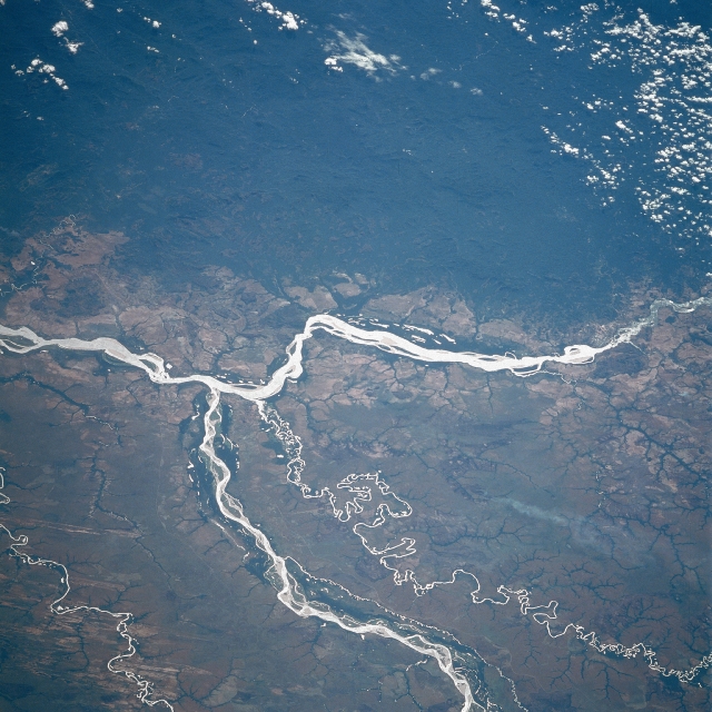 |
| STS61C-36-0029 Orinoco, Meta Rivers, Colombia and Venezuela January 1986 The Orinoco, South America's second longest river extends from right to left across this southeast-looking view. With its headwaters not located until the early 1950's, the river now is estimated to be between 1500 and 1700 miles (2415 to 2735 km) long, making it the eighth longest river in the world. In this scene, the Orinoco skirts the heavily forested Paraguaza Range (upper portion of the image) of the western Guiana Highlands. Entering the scene near the bottom center, the Meta River joins the Orinoco just to the left of center of the image and forms part of the border between Colombia (right or south of the river) and Venezuela (left or north of the river). The small-meandering Bita River is also visible just to the south (right) of the Meta River. A large smoke plume is noticeable to the south (right) of the Bita River. |
| Images: | All Available Images Low-Resolution 356k |
|
| Mission: | STS61C |
|
| Roll - Frame: | 36 - 29 |
|
| Geographical Name: | VENEZUELA |
|
| Features: | RIO ORINOCO,RIO META |
|
| Center Lat x Lon: | 6.0N x 67.5W |
|
| Film Exposure: | N | N=Normal exposure, U=Under exposed, O=Over exposed, F=out of Focus |
| Percentage of Cloud Cover-CLDP: | 10 |
|
| Camera:: | HB |
|
| Camera Tilt: | 45 | LO=Low Oblique, HO=High Oblique, NV=Near Vertical |
| Camera Focal Length: | 250 |
|
| Nadir to Photo Center Direction: | SE | The direction from the nadir to the center point, N=North, S=South, E=East, W=West |
| Stereo?: | N | Y=Yes there is an adjacent picture of the same area, N=No there isn't |
| Orbit Number: | 50 |
|
| Date: | 19860115 | YYYYMMDD |
| Time: | 143818 | GMT HHMMSS |
| Nadir Lat: | 8.0N |
Latitude of suborbital point of spacecraft |
| Nadir Lon: | 69.8W |
Longitude of suborbital point of spacecraft |
| Sun Azimuth: | 132 | Clockwise angle in degrees from north to the sun measured at the nadir point |
| Space Craft Altitude: | 181 | nautical miles |
| Sun Elevation: | 46 | Angle in degrees between the horizon and the sun, measured at the nadir point |
| Land Views: | PLAIN, HILL, FOREST, DUNE |
|
| Water Views: | RIVER, SEDIMENT |
|
| Atmosphere Views: | SMOKE |
|
| Man Made Views: | |
|
| City Views: | |
|
Photo is not associated with any sequences | ||
| NASA Home Page |
JSC Home Page |
JSC Digital Image Collection |
Earth Science & Remote Sensing |
|
This service is provided by the International Space Station program and the JSC Earth Science & Remote Sensing Unit, ARES Division, Exploration Integration Science Directorate.

|