Geographic Region: VENEZUELA
Feature: RIO ORINOCO,R. CAPANAPARO
|
Geographic Region: VENEZUELA Feature: RIO ORINOCO,R. CAPANAPARO |
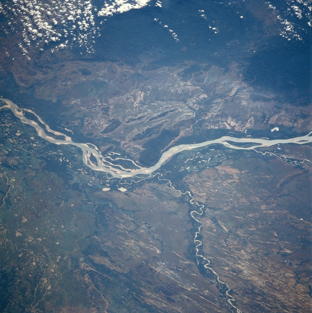 |
| STS61C-36-0028 Orinoco, Capanaparo, and Cinaruco Rivers, Venezuela January 1986 The Orinoco River, the world's eighth largest river, can be seen flowing to the west and north of the Guyana Highlands in the top portion of the image. The river is located in the Llanos of western Venezuela. Estimated to be 1500 to 1700 miles (2415 to 2735 km) long, the Orinoco River is the second longest river in South America and is navigable for most of its length. The river rises in the southern Guyana Highlands and flows in a wide arc around the highlands through tropical rainforests and savannas. It enters the Atlantic Ocean through a large, expanding delta in northeast Venezuela. The Capanaparo River is visible entering the scene just to the right of the bottom center of the image. It empties into the Orinoco River near the center of the image. The Capanaparo River is 300 miles (480 km) long and rises in the eastern foothills of the Andes Mountains. The river flows generally eastward across the plain, which has a flat, swampy terrain. Numerous old sand dunes, many with grass cover, can be seen on either side of the river. Near the left center of the image, the Cinaruco River can be seen entering the Orinoco River. Just above the left center of the image, the Arauca River is visible entering the Orinoco. |
| Images: | All Available Images Low-Resolution 373k |
|
| Mission: | STS61C |
|
| Roll - Frame: | 36 - 28 |
|
| Geographical Name: | VENEZUELA |
|
| Features: | RIO ORINOCO,R. CAPANAPARO |
|
| Center Lat x Lon: | 7.0N x 67W |
|
| Film Exposure: | N | N=Normal exposure, U=Under exposed, O=Over exposed, F=out of Focus |
| Percentage of Cloud Cover-CLDP: | 10 |
|
| Camera:: | HB |
|
| Camera Tilt: | 47 | LO=Low Oblique, HO=High Oblique, NV=Near Vertical |
| Camera Focal Length: | 250 |
|
| Nadir to Photo Center Direction: | E | The direction from the nadir to the center point, N=North, S=South, E=East, W=West |
| Stereo?: | N | Y=Yes there is an adjacent picture of the same area, N=No there isn't |
| Orbit Number: | 50 |
|
| Date: | 19860115 | YYYYMMDD |
| Time: | 143814 | GMT HHMMSS |
| Nadir Lat: | 8.1N |
Latitude of suborbital point of spacecraft |
| Nadir Lon: | 70W |
Longitude of suborbital point of spacecraft |
| Sun Azimuth: | 132 | Clockwise angle in degrees from north to the sun measured at the nadir point |
| Space Craft Altitude: | 181 | nautical miles |
| Sun Elevation: | 46 | Angle in degrees between the horizon and the sun, measured at the nadir point |
| Land Views: | PLAIN, DUNE, HILL |
|
| Water Views: | RIVER, SEDIMENT |
|
| Atmosphere Views: | |
|
| Man Made Views: | |
|
| City Views: | |
|
Photo is not associated with any sequences | ||
| NASA Home Page |
JSC Home Page |
JSC Digital Image Collection |
Earth Science & Remote Sensing |
|
This service is provided by the International Space Station program and the JSC Earth Science & Remote Sensing Unit, ARES Division, Exploration Integration Science Directorate.

|