Geographic Region: BRAZIL
Feature: RIO NEGRO, RIO BRANCO
|
Geographic Region: BRAZIL Feature: RIO NEGRO, RIO BRANCO |
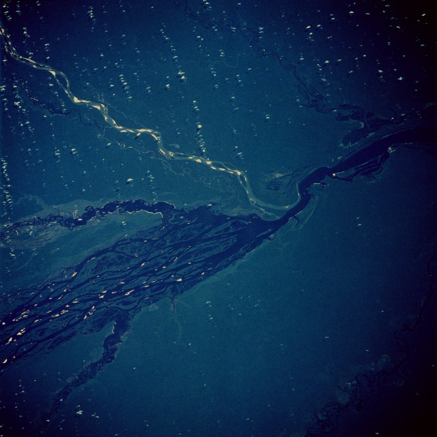 |
| STS61C-33-0072 Rio Negro, Amazonas, Brazil January 1986 One of the major tributaries of Amazon River is the Rio Negro, with its source in the mountains of eastern Colombia and its mouth at Manaus. The Rio Negro, approximately 1400 miles (2255 kilometers) long, is filled with many islands and has many secondary tributaries and channels. This photograph shows five major tributaries entering the Rio Negro approximately 180 miles (290 kilometers) northwest of Manaus, viewing clockwise--the Rio Branco from the north with highly reflective sandbars; the Rio Jauaperi; a portion of the Rio Unini; the Rio Caurés; and the Rio Jufari. The Rio Negro (named for its black color, which results from vegetal debris, not sediment) provides an excellent transportation link for the commercial shipping of rubber and nuts and also for transporting people and general goods to the hinterland of northwestern Brazil. |
| Images: | All Available Images Low-Resolution 103k |
|
| Mission: | STS61C |
|
| Roll - Frame: | 33 - 72 |
|
| Geographical Name: | BRAZIL |
|
| Features: | RIO NEGRO, RIO BRANCO |
|
| Center Lat x Lon: | 1S x 62W |
|
| Film Exposure: | N | N=Normal exposure, U=Under exposed, O=Over exposed, F=out of Focus |
| Percentage of Cloud Cover-CLDP: | 10 |
|
| Camera:: | HB |
|
| Camera Tilt: | LO | LO=Low Oblique, HO=High Oblique, NV=Near Vertical |
| Camera Focal Length: | 250 |
|
| Nadir to Photo Center Direction: | The direction from the nadir to the center point, N=North, S=South, E=East, W=West |
|
| Stereo?: | Y | Y=Yes there is an adjacent picture of the same area, N=No there isn't |
| Orbit Number: | |
|
| Date: | 198601__ | YYYYMMDD |
| Time: | GMT HHMMSS |
|
| Nadir Lat: | N |
Latitude of suborbital point of spacecraft |
| Nadir Lon: | E |
Longitude of suborbital point of spacecraft |
| Sun Azimuth: | Clockwise angle in degrees from north to the sun measured at the nadir point |
|
| Space Craft Altitude: | nautical miles |
|
| Sun Elevation: | Angle in degrees between the horizon and the sun, measured at the nadir point |
|
| Land Views: | PLAIN, FOREST |
|
| Water Views: | RIVER, SWAMP |
|
| Atmosphere Views: | |
|
| Man Made Views: | |
|
| City Views: | |
|
Photo is not associated with any sequences | ||
| NASA Home Page |
JSC Home Page |
JSC Digital Image Collection |
Earth Science & Remote Sensing |
|
This service is provided by the International Space Station program and the JSC Earth Science & Remote Sensing Unit, ARES Division, Exploration Integration Science Directorate.

|