
Geographic Region: MEXICO
Feature: MEXICO CITY BASIN
|
Geographic Region: MEXICO Feature: MEXICO CITY BASIN |
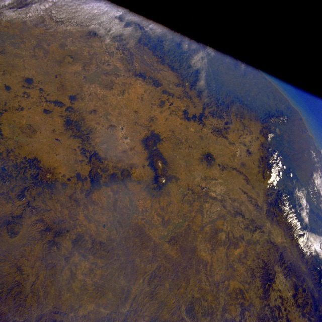 |
| STS61C-32-2 Mexican Plateau (Mexico City Area), Mexico January 1986 The Mexican Plateau covering most of north-central Mexico is a rugged, arid-to-semiarid tableland with an average elevation of 6000 feet (1825 meters) above sea level. This photograph reveals the southern end of this large plateau with its highest elevation of near 8000 feet (2435 meters). The Mexico City Basin is immediately west of three large, north-south-oriented volcanoes (center of the photograph). Snow-covered at its 17 887-foot (5450-meter) summit, Popocatepetl Volcano is the southernmost and highest of these three volcanoes. The single volcano east of this trio is Malinche Volcano, with the rim of its caldera measuring in excess of 14 600 feet (4450 meters) above sea level. The major air stagnation and pollution problems that plague the Mexico City Basin are easily understandable given the physiography of mountainous terrain and volcanic peaks encircling three-quarters of the basin and the massive population within. In l994, Mexico City had a population of more than 22 million, making it the second most populous metropolitan area on Earth. Some demographers predict that Mexico City will have 40 to 50 million people by 2010. |
| Images: | All Available Images Low-Resolution 120k |
|
| Mission: | STS61C |
|
| Roll - Frame: | 32 - 2 |
|
| Geographical Name: | MEXICO |
|
| Features: | MEXICO CITY BASIN |
|
| Center Lat x Lon: | 19.0N x 98.5W |
|
| Film Exposure: | N | N=Normal exposure, U=Under exposed, O=Over exposed, F=out of Focus |
| Percentage of Cloud Cover-CLDP: | 20 |
|
| Camera:: | HB |
|
| Camera Tilt: | 26 | LO=Low Oblique, HO=High Oblique, NV=Near Vertical |
| Camera Focal Length: | 50 |
|
| Nadir to Photo Center Direction: | E | The direction from the nadir to the center point, N=North, S=South, E=East, W=West |
| Stereo?: | N | Y=Yes there is an adjacent picture of the same area, N=No there isn't |
| Orbit Number: | 4 |
|
| Date: | 19860112 | YYYYMMDD |
| Time: | 164349 | GMT HHMMSS |
| Nadir Lat: | 18.4N |
Latitude of suborbital point of spacecraft |
| Nadir Lon: | 99.8W |
Longitude of suborbital point of spacecraft |
| Sun Azimuth: | 141 | Clockwise angle in degrees from north to the sun measured at the nadir point |
| Space Craft Altitude: | 176 | nautical miles |
| Sun Elevation: | 39 | Angle in degrees between the horizon and the sun, measured at the nadir point |
| Land Views: | PLATEAU, MOUNTAIN, DESERT, VOLCANO |
|
| Water Views: | |
|
| Atmosphere Views: | |
|
| Man Made Views: | POLLUTION |
|
| City Views: | |
|
Photo is not associated with any sequences | ||
| NASA Home Page |
JSC Home Page |
JSC Digital Image Collection |
Earth Science & Remote Sensing |
|
This service is provided by the International Space Station program and the JSC Earth Science & Remote Sensing Unit, ARES Division, Exploration Integration Science Directorate.

|