
Geographic Region: NICARAGUA
Feature: L. MANAGUA, VOL,MANAGUA
|
Geographic Region: NICARAGUA Feature: L. MANAGUA, VOL,MANAGUA |
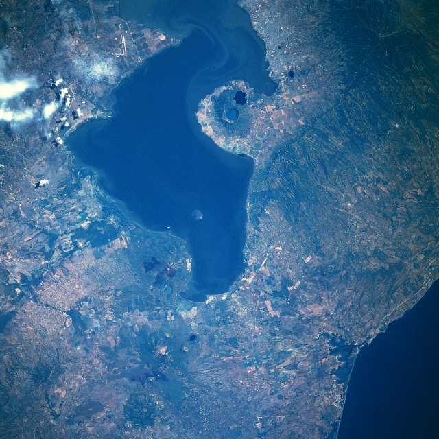 |
| STS61C-31-0051 Lake Managua, Nicaragua January 1986 The second largest freshwater lake in Central America, Lake Managua can be seen in this west-southwest-looking view. Located in a rift valley, Lake Managua is 34 miles (56 km) long and 15 miles (24 km) wide. Lake Nicaragua is drained by the San Juan River, which flows east-southeast through a rift valley and empties into the Caribbean Sea. Also visible in this view are a number of volcanoes and volcano craters. This line of young volcanoes lie about 47 miles (75 km) inland from the Pacific Ocean (upper left) and are just to the west of a large coastal fracture or structural rift. The soils around the volcanoes are very fertile, and numerous agricultural field patterns are discernible scattered throughout the image. Just to the left of the bottom center of the image is the capital city of Managua, the industrial and commercial center of the country. The climate of the city is normally very hot and sultry. The city has been prone to many destructive earthquakes during its history, the last one occurring December 23, 1972 when Managua was almost completely destroyed and more than 10000 lives were lost. |
| Images: | All Available Images Low-Resolution 400k |
|
| Mission: | STS61C |
|
| Roll - Frame: | 31 - 51 |
|
| Geographical Name: | NICARAGUA |
|
| Features: | L. MANAGUA, VOL,MANAGUA |
|
| Center Lat x Lon: | 12.5N x 86.5W |
|
| Film Exposure: | N | N=Normal exposure, U=Under exposed, O=Over exposed, F=out of Focus |
| Percentage of Cloud Cover-CLDP: | 10 |
|
| Camera:: | HB |
|
| Camera Tilt: | 20 | LO=Low Oblique, HO=High Oblique, NV=Near Vertical |
| Camera Focal Length: | 250 |
|
| Nadir to Photo Center Direction: | NW | The direction from the nadir to the center point, N=North, S=South, E=East, W=West |
| Stereo?: | Y | Y=Yes there is an adjacent picture of the same area, N=No there isn't |
| Orbit Number: | 4 |
|
| Date: | 19860112 | YYYYMMDD |
| Time: | 164833 | GMT HHMMSS |
| Nadir Lat: | 11.8N |
Latitude of suborbital point of spacecraft |
| Nadir Lon: | 85.7W |
Longitude of suborbital point of spacecraft |
| Sun Azimuth: | 155 | Clockwise angle in degrees from north to the sun measured at the nadir point |
| Space Craft Altitude: | 176 | nautical miles |
| Sun Elevation: | 53 | Angle in degrees between the horizon and the sun, measured at the nadir point |
| Land Views: | VOLCANO, ESCARPMENT |
|
| Water Views: | LAKE |
|
| Atmosphere Views: | |
|
| Man Made Views: | AGRICULTURE, PIVOT IRRIGATION, URBAN AREA |
|
| City Views: | |
|
Photo is not associated with any sequences | ||
| NASA Home Page |
JSC Home Page |
JSC Digital Image Collection |
Earth Science & Remote Sensing |
|
This service is provided by the International Space Station program and the JSC Earth Science & Remote Sensing Unit, ARES Division, Exploration Integration Science Directorate.

|