
Geographic Region: EL SALVADOR
Feature: VOL. SAN MIGUEL, COAST
|
Geographic Region: EL SALVADOR Feature: VOL. SAN MIGUEL, COAST |
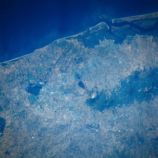 |
| STS61C-31-0047 San Miguel Volcano, El Salvador January 1986 Located on the image just to the right center, the symmetrical cone of San Miguel Volcano can be seen in this south-southwest-looking view. A stratovolcano, San Miguel rises to an elevation of 6993 feet (2123 meters) and has a diameter at its base of approximately 8 miles (13 km). The volcano is one of El Salvador's most prominent landmarks and one of its most frequently active volcanoes. The city of San Miguel (not discernible on the image) sits at the foot of the volcano on its west flank. The city of over 150000 in population is at risk from a possible future eruption. The area around the volcano is mostly agricultural due to the abundance of good volcanic soils. Coffee plantations extend up the flanks of the volcano. There have been 28 confirmed eruptions of the volcano since the year 1500. Most of the eruptions have been short-lived events that produced lava flows and ash fall. The last minor eruptions occurred in the winter of 1986 and again in March of 1995. Steam can be seen at the summit of the volcano on this 1986 image. Extinct volcanoes are visible to the west (right) of San Miguel Volcano. |
| Images: | All Available Images Low-Resolution 403k |
|
| Mission: | STS61C |
|
| Roll - Frame: | 31 - 47 |
|
| Geographical Name: | EL SALVADOR |
|
| Features: | VOL. SAN MIGUEL, COAST |
|
| Center Lat x Lon: | 13.5N x 88W |
|
| Film Exposure: | N | N=Normal exposure, U=Under exposed, O=Over exposed, F=out of Focus |
| Percentage of Cloud Cover-CLDP: | 0 |
|
| Camera:: | HB |
|
| Camera Tilt: | 10 | LO=Low Oblique, HO=High Oblique, NV=Near Vertical |
| Camera Focal Length: | 250 |
|
| Nadir to Photo Center Direction: | N | The direction from the nadir to the center point, N=North, S=South, E=East, W=West |
| Stereo?: | Y | Y=Yes there is an adjacent picture of the same area, N=No there isn't |
| Orbit Number: | 4 |
|
| Date: | 19860112 | YYYYMMDD |
| Time: | 164751 | GMT HHMMSS |
| Nadir Lat: | 13.0N |
Latitude of suborbital point of spacecraft |
| Nadir Lon: | 88.1W |
Longitude of suborbital point of spacecraft |
| Sun Azimuth: | 152 | Clockwise angle in degrees from north to the sun measured at the nadir point |
| Space Craft Altitude: | 176 | nautical miles |
| Sun Elevation: | 51 | Angle in degrees between the horizon and the sun, measured at the nadir point |
| Land Views: | UPLAND, VOLCANO |
|
| Water Views: | |
|
| Atmosphere Views: | PLUME |
|
| Man Made Views: | AGRICULTURE |
|
| City Views: | |
|
Photo is not associated with any sequences | ||
| NASA Home Page |
JSC Home Page |
JSC Digital Image Collection |
Earth Science & Remote Sensing |
|
This service is provided by the International Space Station program and the JSC Earth Science & Remote Sensing Unit, ARES Division, Exploration Integration Science Directorate.

|