
Geographic Region: EL SALVADOR
Feature: VOL. SANTA ANA,L. COATEPEQ
|
Geographic Region: EL SALVADOR Feature: VOL. SANTA ANA,L. COATEPEQ |
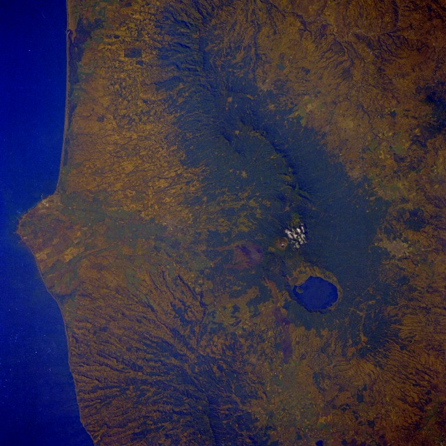 |
| STS61C-31-0045 Santa Ana Volcano, El Salvador January 1986 El Salvador, a land of volcanoes, lies within the volcanic axis that crosses Central America in a northwest-southeast alignment from Mexico to Panama. Several volcanic features are visible in this near-vertical photograph of the Santa Ana Volcano--the very large, steep-sided, water-filled caldera that measures more than 3 miles (5 kilometers) at its maximum width; a patch of clouds near the summit of the crater almost 7800 feet (2380 meters) above sea level; and a flank volcano (gray, nonvegetated area) south of the main crater. The flank volcano is believed to have been the source of the last eruption (1920) and resultant lava flows. The protruding land mass that disrupts the otherwise smooth Pacific Ocean coastline is believed to have been formed by a large lava flow from the main volcanic source area. Other vegetated volcanic ridges with the classic radial drainage pattern can be identified west and southeast of the Santa Ana Volcano. The small city of Santa Ana is barely visible north of the large water-filled caldera. The capital city of San Salvador (not in this photograph) is located approximately 25 miles (40 kilometers) southeast of the Santa Ana Volcano. |
| Images: | All Available Images Low-Resolution 143k |
|
| Mission: | STS61C |
|
| Roll - Frame: | 31 - 45 |
|
| Geographical Name: | EL SALVADOR |
|
| Features: | VOL. SANTA ANA,L. COATEPEQ |
|
| Center Lat x Lon: | 13.5N x 89.5W |
|
| Film Exposure: | N | N=Normal exposure, U=Under exposed, O=Over exposed, F=out of Focus |
| Percentage of Cloud Cover-CLDP: | 5 |
|
| Camera:: | HB |
|
| Camera Tilt: | 4 | LO=Low Oblique, HO=High Oblique, NV=Near Vertical |
| Camera Focal Length: | 250 |
|
| Nadir to Photo Center Direction: | S | The direction from the nadir to the center point, N=North, S=South, E=East, W=West |
| Stereo?: | N | Y=Yes there is an adjacent picture of the same area, N=No there isn't |
| Orbit Number: | 4 |
|
| Date: | 19860112 | YYYYMMDD |
| Time: | 164727 | GMT HHMMSS |
| Nadir Lat: | 13.7N |
Latitude of suborbital point of spacecraft |
| Nadir Lon: | 89.5W |
Longitude of suborbital point of spacecraft |
| Sun Azimuth: | 150 | Clockwise angle in degrees from north to the sun measured at the nadir point |
| Space Craft Altitude: | 176 | nautical miles |
| Sun Elevation: | 49 | Angle in degrees between the horizon and the sun, measured at the nadir point |
| Land Views: | VOLCANO, MOUNTAIN, CRATER, COAST, PLAIN |
|
| Water Views: | OCEAN |
|
| Atmosphere Views: | |
|
| Man Made Views: | |
|
| City Views: | |
|
Photo is not associated with any sequences | ||
| NASA Home Page |
JSC Home Page |
JSC Digital Image Collection |
Earth Science & Remote Sensing |
|
This service is provided by the International Space Station program and the JSC Earth Science & Remote Sensing Unit, ARES Division, Exploration Integration Science Directorate.

|