
Geographic Region: MEXICO
Feature: COLIMA VOLCANO PLUME
|
Geographic Region: MEXICO Feature: COLIMA VOLCANO PLUME |
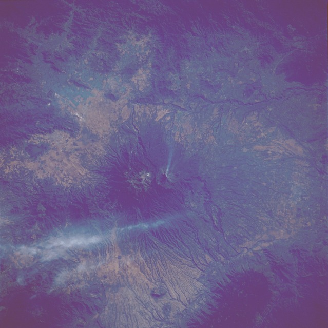 |
| STS61C-31-0035 Colima Massif, Mexico January 1986 The smoking Colima Volcano (center of the photograph, with the direction of its plume flowing west to east) can be seen in this near-vertical photograph. The volcano, which is more than 13 990 feet (4264 meters) above sea level, is part of a larger structure, the Colima Massif, which is visible above it. These mountains are about 75 miles (120 kilometers) south of Guadalajara (the city is not on the photograph). Colima has been Mexico's most active volcano, with a total of 49 recorded eruptions since 1560. Light brown ash covers the summits of both peaks. The dark green forested regions cover the flanks of the massif and turn to a lighter green over the agricultural region at the base of the massif and throughout the surrounding valleys. To the north of the Colima Massif, the small city of Guzman and a small lake can be seen. The canyon of the Tamazula River is visible running north-south to the east of the Colima Massif. To the southwest of the Colima Volcano, the canyon of the Comala River can be seen. High, thin cirrus clouds extend northward just to the west of the Colima Massif. |
| Images: | All Available Images Low-Resolution 96k |
|
| Mission: | STS61C |
|
| Roll - Frame: | 31 - 35 |
|
| Geographical Name: | MEXICO |
|
| Features: | COLIMA VOLCANO PLUME |
|
| Center Lat x Lon: | 19.5N x 103.5W |
|
| Film Exposure: | N | N=Normal exposure, U=Under exposed, O=Over exposed, F=out of Focus |
| Percentage of Cloud Cover-CLDP: | 10 |
|
| Camera:: | HB |
|
| Camera Tilt: | 17 | LO=Low Oblique, HO=High Oblique, NV=Near Vertical |
| Camera Focal Length: | 250 |
|
| Nadir to Photo Center Direction: | SE | The direction from the nadir to the center point, N=North, S=South, E=East, W=West |
| Stereo?: | Y | Y=Yes there is an adjacent picture of the same area, N=No there isn't |
| Orbit Number: | 4 |
|
| Date: | 19860112 | YYYYMMDD |
| Time: | 164319 | GMT HHMMSS |
| Nadir Lat: | 20.1N |
Latitude of suborbital point of spacecraft |
| Nadir Lon: | 104.2W |
Longitude of suborbital point of spacecraft |
| Sun Azimuth: | 138 | Clockwise angle in degrees from north to the sun measured at the nadir point |
| Space Craft Altitude: | 177 | nautical miles |
| Sun Elevation: | 35 | Angle in degrees between the horizon and the sun, measured at the nadir point |
| Land Views: | VOLCANO, CRATER, FOREST |
|
| Water Views: | |
|
| Atmosphere Views: | PLUME |
|
| Man Made Views: | |
|
| City Views: | |
|
Photo is not associated with any sequences | ||
| NASA Home Page |
JSC Home Page |
JSC Digital Image Collection |
Earth Science & Remote Sensing |
|
This service is provided by the International Space Station program and the JSC Earth Science & Remote Sensing Unit, ARES Division, Exploration Integration Science Directorate.

|