
Geographic Region: MYANMAR (BURMA)
Feature: MOUTHS OF THE IRRAWADDY
|
Geographic Region: MYANMAR (BURMA) Feature: MOUTHS OF THE IRRAWADDY |
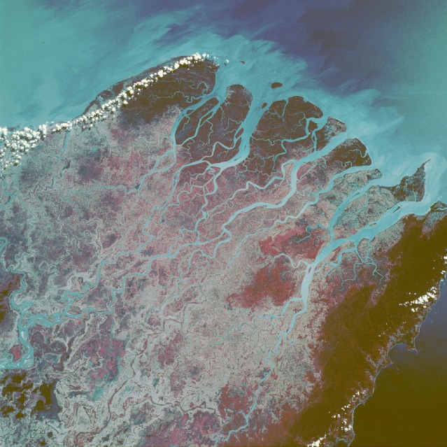 |
| STS61B-49-0101 Mouths of the Irrawaddy River, Burma (Myanmar) November 1985 Infrared film helps accentuate plant growth and sediment accumulations in this near-vertical photograph of the numerous mouths of the Irrawaddy River in western Burma. The Irrawaddy Delta, one of the world's great rice-producing regions, consists of fertile river mud and sand deposited during the last 2 million years. The southernmost extent of the low, forested Arakan Yoma Mountain Range can be seen along the western edge of the photograph. This north-south trending mountain range is usually well watered by the summer monsoons that severely impact the environments of Bangladesh and northeastern India. The deep reds indicate a healthy forest region that is wholly dependent on the summer monsoons for its major precipitation, to the extent that the area is classified as a monsoon rain forest. The deep reds at the southern end of the multichanneled delta reflect large mangrove forests. The light blues show the sediment plumes within the stream channels extending southward into the Andaman Sea. |
| Images: | All Available Images Low-Resolution 145k |
|
| Mission: | STS61B |
|
| Roll - Frame: | 49 - 101 |
|
| Geographical Name: | MYANMAR (BURMA) |
|
| Features: | MOUTHS OF THE IRRAWADDY |
|
| Center Lat x Lon: | 16.5N x 95.0E |
|
| Film Exposure: | N | N=Normal exposure, U=Under exposed, O=Over exposed, F=out of Focus |
| Percentage of Cloud Cover-CLDP: | 20 |
|
| Camera:: | HB |
|
| Camera Tilt: | 15 | LO=Low Oblique, HO=High Oblique, NV=Near Vertical |
| Camera Focal Length: | 100 |
|
| Nadir to Photo Center Direction: | S | The direction from the nadir to the center point, N=North, S=South, E=East, W=West |
| Stereo?: | N | Y=Yes there is an adjacent picture of the same area, N=No there isn't |
| Orbit Number: | 68 |
|
| Date: | 19851201 | YYYYMMDD |
| Time: | 064614 | GMT HHMMSS |
| Nadir Lat: | 17.2N |
Latitude of suborbital point of spacecraft |
| Nadir Lon: | 94.7E |
Longitude of suborbital point of spacecraft |
| Sun Azimuth: | 206 | Clockwise angle in degrees from north to the sun measured at the nadir point |
| Space Craft Altitude: | 172 | nautical miles |
| Sun Elevation: | 46 | Angle in degrees between the horizon and the sun, measured at the nadir point |
| Land Views: | COAST, FOREST, MOUNTAIN, PLAIN, PENINSULA |
|
| Water Views: | RIVER, ESTUARY, DELTA, SEDIMENT, SWAMP, CHANNEL |
|
| Atmosphere Views: | |
|
| Man Made Views: | AGRICULTURE |
|
| City Views: | |
|
Photo is not associated with any sequences | ||
| NASA Home Page |
JSC Home Page |
JSC Digital Image Collection |
Earth Science & Remote Sensing |
|
This service is provided by the International Space Station program and the JSC Earth Science & Remote Sensing Unit, ARES Division, Exploration Integration Science Directorate.

|