
Geographic Region: AUSTRALIA-NT
Feature: JAMES RANGES, FINKE RIV.
|
Geographic Region: AUSTRALIA-NT Feature: JAMES RANGES, FINKE RIV. |
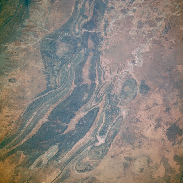 |
| STS61B-44-6 Mountain Ranges, Northern Territory, Australia November 1985 This photograph shows a series of northwest-southeast-trending mountains, most of which rise less than 2500 feet (800 meters) above sea level, near the geographic center of Australia. These ranges--James, Gardiner's, Middle, Krichauff, and George Gills--lie south-southwest of the more well-known Macdonnell Ranges. Several features are discernible in the photograph--the southeast-flowing Finke River near the eastern edge of the photograph; circular Gosses Bluff, an impact crater (northern edge of the photograph), which lies in the arid, flat Missionary Plain between the Macdonnell Ranges to the north (partially visible in the northeast corner of the photograph) and the James Range to the south; and an area of sand ridges south of these low, folded ranges. |
| Images: | All Available Images Low-Resolution 134k |
|
| Mission: | STS61B |
|
| Roll - Frame: | 44 - 6 |
|
| Geographical Name: | AUSTRALIA-NT |
|
| Features: | JAMES RANGES, FINKE RIV. |
|
| Center Lat x Lon: | 24.5S x 132.5E |
|
| Film Exposure: | N | N=Normal exposure, U=Under exposed, O=Over exposed, F=out of Focus |
| Percentage of Cloud Cover-CLDP: | 0 |
|
| Camera:: | HB |
|
| Camera Tilt: | 52 | LO=Low Oblique, HO=High Oblique, NV=Near Vertical |
| Camera Focal Length: | 250 |
|
| Nadir to Photo Center Direction: | E | The direction from the nadir to the center point, N=North, S=South, E=East, W=West |
| Stereo?: | N | Y=Yes there is an adjacent picture of the same area, N=No there isn't |
| Orbit Number: | 16 |
|
| Date: | 19851128 | YYYYMMDD |
| Time: | 002012 | GMT HHMMSS |
| Nadir Lat: | 24S |
Latitude of suborbital point of spacecraft |
| Nadir Lon: | 128.3E |
Longitude of suborbital point of spacecraft |
| Sun Azimuth: | 95 | Clockwise angle in degrees from north to the sun measured at the nadir point |
| Space Craft Altitude: | 197 | nautical miles |
| Sun Elevation: | 49 | Angle in degrees between the horizon and the sun, measured at the nadir point |
| Land Views: | DESERT, MOUNTAIN, RANGE |
|
| Water Views: | RIVER |
|
| Atmosphere Views: | |
|
| Man Made Views: | |
|
| City Views: | |
|
Photo is not associated with any sequences | ||
| NASA Home Page |
JSC Home Page |
JSC Digital Image Collection |
Earth Science & Remote Sensing |
|
This service is provided by the International Space Station program and the JSC Earth Science & Remote Sensing Unit, ARES Division, Exploration Integration Science Directorate.

|