
Geographic Region: USA-ARIZONA
Feature: GRAND CANYON
|
Geographic Region: USA-ARIZONA Feature: GRAND CANYON |
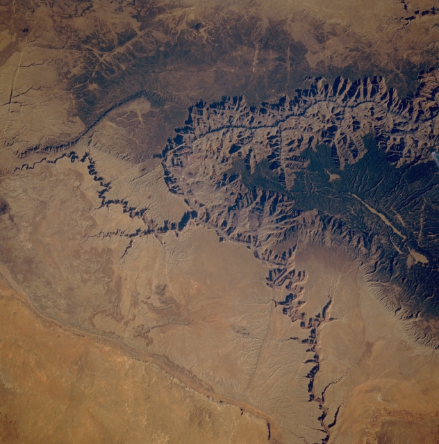 |
| STS61A-48-91 Grand Canyon, Arizona, U.S.A. November 1985 The eastern end of the deeply incised Grand Canyon of northwestern Arizona is visible in the upper third of this low-oblique, southwestern-looking photograph. As the Colorado River makes a great turn to the north, the northwest-flowing Little Colorado River joins it from the east; north of this confluence is Marble Canyon. The forested, elevated land north of the big bend in the Colorado River is the Kaibab Plateau, on whose southern tip is the North Rim, an outstanding observation point for viewing the Grand Canyon. Echo Cliffs Range appears as a dramatic change in topography near the lower left corner of the photograph, and southwest of this a small part of the Painted Desert is discernible. The darker colors are areas on the plateaus north and south of the Grand Canyon where vegetation is more dense. |
| Images: | All Available Images Low-Resolution 340k |
|
| Mission: | STS61A |
|
| Roll - Frame: | 48 - 91 |
|
| Geographical Name: | USA-ARIZONA |
|
| Features: | GRAND CANYON |
|
| Center Lat x Lon: | 36.0N x 112W |
|
| Film Exposure: | N | N=Normal exposure, U=Under exposed, O=Over exposed, F=out of Focus |
| Percentage of Cloud Cover-CLDP: | 0 |
|
| Camera:: | HB |
|
| Camera Tilt: | 38 | LO=Low Oblique, HO=High Oblique, NV=Near Vertical |
| Camera Focal Length: | 250 |
|
| Nadir to Photo Center Direction: | SW | The direction from the nadir to the center point, N=North, S=South, E=East, W=West |
| Stereo?: | N | Y=Yes there is an adjacent picture of the same area, N=No there isn't |
| Orbit Number: | 65 |
|
| Date: | 19851103 | YYYYMMDD |
| Time: | 181424 | GMT HHMMSS |
| Nadir Lat: | 37.9N |
Latitude of suborbital point of spacecraft |
| Nadir Lon: | 110.6W |
Longitude of suborbital point of spacecraft |
| Sun Azimuth: | 164 | Clockwise angle in degrees from north to the sun measured at the nadir point |
| Space Craft Altitude: | 179 | nautical miles |
| Sun Elevation: | 35 | Angle in degrees between the horizon and the sun, measured at the nadir point |
| Land Views: | DESERT, PLATEAU |
|
| Water Views: | RIVER |
|
| Atmosphere Views: | |
|
| Man Made Views: | |
|
| City Views: | |
|
Photo is not associated with any sequences | ||
| NASA Home Page |
JSC Home Page |
JSC Digital Image Collection |
Earth Science & Remote Sensing |
|
This service is provided by the International Space Station program and the JSC Earth Science & Remote Sensing Unit, ARES Division, Exploration Integration Science Directorate.

|