
Geographic Region: USA-ARIZONA
Feature: LAKE MEAD
|
Geographic Region: USA-ARIZONA Feature: LAKE MEAD |
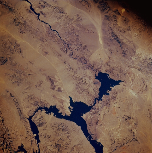 |
| STS61A-048-0088 Lake Mead, Arizona, U.S.A. November 1985 This low-oblique, southwest-looking photograph of northwest Arizona and southeast Nevada shows a desert landscape dominated by spectacular features. Lake Mead, formed by Hoover Dam (formerly Boulder Dam), and the Colorado River constitute part of the boundary between the two states. Although Hoover Dam, which was completed in 1936, was originally constructed to provide flood control, irrigation, power, and river regulation, adjacent Lake Mead has become a major recreational site. Increasing tourism and the growing population of Las Vegas, Nevada, (part of which is visible along the right edge of the photograph) have placed heavier demands on Lake Mead. Part of a drainage system--light, linear Detrital Wash--extends southward from the middle of Lake Mead. Using Las Vegas as a starting point, several mountains are visible--to the northeast, the Virgin Mountains on a large peninsula that extends southward; to the east, the Muddy Mountains; to the southeast, the Black Mountains (in Arizona) and Eldorado Mountains (in Nevada), which are located on either side of the Colorado River south of Hoover Dam; and to the south, the McCullough Mountains. The lighter, elongated area southeast of the McCullough Mountains is a dry lakebed (playa). |
| Images: | All Available Images Low-Resolution 345k |
|
| Mission: | STS61A |
|
| Roll - Frame: | 48 - 88 |
|
| Geographical Name: | USA-ARIZONA |
|
| Features: | LAKE MEAD |
|
| Center Lat x Lon: | 36.0N x 114.5W |
|
| Film Exposure: | N | N=Normal exposure, U=Under exposed, O=Over exposed, F=out of Focus |
| Percentage of Cloud Cover-CLDP: | 0 |
|
| Camera:: | HB |
|
| Camera Tilt: | 40 | LO=Low Oblique, HO=High Oblique, NV=Near Vertical |
| Camera Focal Length: | 250 |
|
| Nadir to Photo Center Direction: | W | The direction from the nadir to the center point, N=North, S=South, E=East, W=West |
| Stereo?: | N | Y=Yes there is an adjacent picture of the same area, N=No there isn't |
| Orbit Number: | 65 |
|
| Date: | 19851103 | YYYYMMDD |
| Time: | 181355 | GMT HHMMSS |
| Nadir Lat: | 36.5N |
Latitude of suborbital point of spacecraft |
| Nadir Lon: | 112.1W |
Longitude of suborbital point of spacecraft |
| Sun Azimuth: | 162 | Clockwise angle in degrees from north to the sun measured at the nadir point |
| Space Craft Altitude: | 178 | nautical miles |
| Sun Elevation: | 36 | Angle in degrees between the horizon and the sun, measured at the nadir point |
| Land Views: | DESERT |
|
| Water Views: | LAKE, RIVER |
|
| Atmosphere Views: | |
|
| Man Made Views: | |
|
| City Views: | |
|
Photo is not associated with any sequences | ||
| NASA Home Page |
JSC Home Page |
JSC Digital Image Collection |
Earth Science & Remote Sensing |
|
This service is provided by the International Space Station program and the JSC Earth Science & Remote Sensing Unit, ARES Division, Exploration Integration Science Directorate.

|