
Geographic Region: USA-TEXAS
Feature: GALVESTON BAY
|
Geographic Region: USA-TEXAS Feature: GALVESTON BAY |
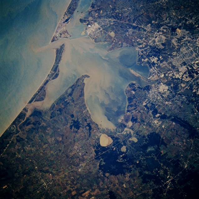 |
| STS61A-048-0077 Galveston Bay, Texas, U.S.A. November 1985 Sediment-laden Galveston Bay, which occupies the drowned mouths of the Trinity River and the San Jacinto River, is featured in this south-southwest-looking, low-oblique photograph. The bay presently averages 12 feet (4 meters) in depth; however, at the end of the last ice age, melting glaciers caused the sea level to rise approximately 400 feet (122 meters). A ship channel allows large merchant ships into the Port of Houston, the third-busiest port in the United States. Apparent are Trinity Bay (center of the photograph); the mouth of the Trinity River (bottom left) with its vast load of sediment at the north end of the bay; sediment-filled, circular Lake Anahuac east of the Trinity River mouth; southeast Houston and the small port city of Baytown; and Galveston near the southern portion of Galveston Bay (top center). |
| Images: | All Available Images Low-Resolution 370k |
|
| Mission: | STS61A |
|
| Roll - Frame: | 48 - 77 |
|
| Geographical Name: | USA-TEXAS |
|
| Features: | GALVESTON BAY |
|
| Center Lat x Lon: | 29.5N x 94.5W |
|
| Film Exposure: | N | N=Normal exposure, U=Under exposed, O=Over exposed, F=out of Focus |
| Percentage of Cloud Cover-CLDP: | 0 |
|
| Camera:: | HB |
|
| Camera Tilt: | 27 | LO=Low Oblique, HO=High Oblique, NV=Near Vertical |
| Camera Focal Length: | 250 |
|
| Nadir to Photo Center Direction: | S | The direction from the nadir to the center point, N=North, S=South, E=East, W=West |
| Stereo?: | N | Y=Yes there is an adjacent picture of the same area, N=No there isn't |
| Orbit Number: | 64 |
|
| Date: | 19851103 | YYYYMMDD |
| Time: | 164104 | GMT HHMMSS |
| Nadir Lat: | 31.0N |
Latitude of suborbital point of spacecraft |
| Nadir Lon: | 94.2W |
Longitude of suborbital point of spacecraft |
| Sun Azimuth: | 154 | Clockwise angle in degrees from north to the sun measured at the nadir point |
| Space Craft Altitude: | 177 | nautical miles |
| Sun Elevation: | 40 | Angle in degrees between the horizon and the sun, measured at the nadir point |
| Land Views: | PLAIN, COAST |
|
| Water Views: | BAY, SEDIMENT, RIVER, GULF |
|
| Atmosphere Views: | |
|
| Man Made Views: | |
|
| City Views: | |
|
Photo is not associated with any sequences | ||
| NASA Home Page |
JSC Home Page |
JSC Digital Image Collection |
Earth Science & Remote Sensing |
|
This service is provided by the International Space Station program and the JSC Earth Science & Remote Sensing Unit, ARES Division, Exploration Integration Science Directorate.

|