
Geographic Region: USA-TEXAS
Feature: GALVESTON BAY
|
Geographic Region: USA-TEXAS Feature: GALVESTON BAY |
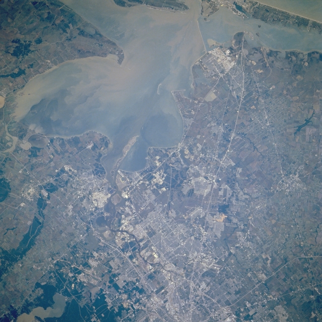 |
| STS61A-048-0073 Southeast Houston and Galveston Bay, Texas, U.S.A. November 1985 Sediment-laden Galveston Bay and surrounding communities are featured in the east-southeast-looking, low-oblique photograph. Much of the sediment enters Galveston Bay from the mouth of the Trinity River (slightly above left center). Covering the former mouths and estuaries of both the Trinity River and San Jacinto River, Galveston Bay is a shallow bay with an average depth of 12 feet (4 meters). Dredging allows the entrance of large merchant ships into the bay from the Gulf of Mexico and access to the Port of Houston, the third-busiest port in the United States. Apparent is the snakelike Houston Ship Channel, 57 miles (92 kilometers) long, 200 feet (61 meters) wide, and 34 feet (10 meters) deep, bounded by petrochemical facilities, oil refineries, and numerous other industries along its banks. Visible are Interstate Highway 45 traversing from the center of Houston southeastward to Galveston Island; Lake Houston (lower left); and Clear Lake City, home of the NASA Lyndon B. Johnson Space Center (right of center). |
| Images: | All Available Images Low-Resolution 346k |
|
| Mission: | STS61A |
|
| Roll - Frame: | 48 - 73 |
|
| Geographical Name: | USA-TEXAS |
|
| Features: | GALVESTON BAY |
|
| Center Lat x Lon: | 29.5N x 95W |
|
| Film Exposure: | N | N=Normal exposure, U=Under exposed, O=Over exposed, F=out of Focus |
| Percentage of Cloud Cover-CLDP: | 0 |
|
| Camera:: | HB |
|
| Camera Tilt: | 9 | LO=Low Oblique, HO=High Oblique, NV=Near Vertical |
| Camera Focal Length: | 250 |
|
| Nadir to Photo Center Direction: | SE | The direction from the nadir to the center point, N=North, S=South, E=East, W=West |
| Stereo?: | Y | Y=Yes there is an adjacent picture of the same area, N=No there isn't |
| Orbit Number: | 64 |
|
| Date: | 19851103 | YYYYMMDD |
| Time: | 164038 | GMT HHMMSS |
| Nadir Lat: | 29.7N |
Latitude of suborbital point of spacecraft |
| Nadir Lon: | 95.4W |
Longitude of suborbital point of spacecraft |
| Sun Azimuth: | 152 | Clockwise angle in degrees from north to the sun measured at the nadir point |
| Space Craft Altitude: | 177 | nautical miles |
| Sun Elevation: | 40 | Angle in degrees between the horizon and the sun, measured at the nadir point |
| Land Views: | PLAIN |
|
| Water Views: | BAY, SEDIMENT, CHANNEL, LAKE |
|
| Atmosphere Views: | |
|
| Man Made Views: | HIGHWAY, AIRPORT |
|
| City Views: | |
|
Photo is not associated with any sequences | ||
| NASA Home Page |
JSC Home Page |
JSC Digital Image Collection |
Earth Science & Remote Sensing |
|
This service is provided by the International Space Station program and the JSC Earth Science & Remote Sensing Unit, ARES Division, Exploration Integration Science Directorate.

|