
Geographic Region: USA-TEXAS
Feature: CORPUS CHRISTI
|
Geographic Region: USA-TEXAS Feature: CORPUS CHRISTI |
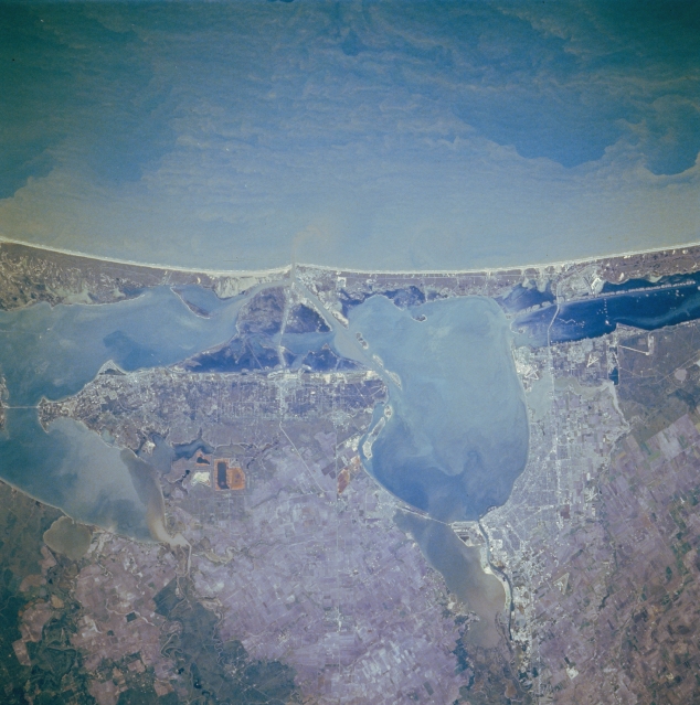 |
| STS61A-048-0070 Corpus Christi and Aransas Pass, Texas, U.S.A. November 1985 Corpus Christi and Aransas Pass are featured in this southeast-looking, low-oblique photograph. Corpus Christi, on the western shore of Corpus Christi Bay, is a petroleum and natural gas center with much heavy industry. Important to the city's economy are oil refineries, smelting plants, chemical works, fishing and shrimping, and tourism. The Corpus Christi Naval Air Station is east of the city near the Intracoastal Waterway and the causeway to Padre Island, a barrier island. Visible are sediment-laden Corpus Christi Bay, a shallow inlet of the Gulf of Mexico, and Nueces Bay, separated by a causeway to the west. Nueces Bay covers the former mouth of the Nueces River, which extended into Corpus Christi Bay when sea levels were lower during the last ice age. Following the northeast curve of the mainland above Corpus Christi Bay are Aransas Pass, a resort and fishing center for south Texas; Aransas Bay; and Copano Bay to its west. |
| Images: | All Available Images Low-Resolution 317k |
|
| Mission: | STS61A |
|
| Roll - Frame: | 48 - 70 |
|
| Geographical Name: | USA-TEXAS |
|
| Features: | CORPUS CHRISTI |
|
| Center Lat x Lon: | 28.0N x 97W |
|
| Film Exposure: | N | N=Normal exposure, U=Under exposed, O=Over exposed, F=out of Focus |
| Percentage of Cloud Cover-CLDP: | 0 |
|
| Camera:: | HB |
|
| Camera Tilt: | 10 | LO=Low Oblique, HO=High Oblique, NV=Near Vertical |
| Camera Focal Length: | 250 |
|
| Nadir to Photo Center Direction: | SW | The direction from the nadir to the center point, N=North, S=South, E=East, W=West |
| Stereo?: | N | Y=Yes there is an adjacent picture of the same area, N=No there isn't |
| Orbit Number: | 64 |
|
| Date: | 19851103 | YYYYMMDD |
| Time: | 164010 | GMT HHMMSS |
| Nadir Lat: | 28.3N |
Latitude of suborbital point of spacecraft |
| Nadir Lon: | 96.6W |
Longitude of suborbital point of spacecraft |
| Sun Azimuth: | 150 | Clockwise angle in degrees from north to the sun measured at the nadir point |
| Space Craft Altitude: | 177 | nautical miles |
| Sun Elevation: | 41 | Angle in degrees between the horizon and the sun, measured at the nadir point |
| Land Views: | COAST, PLAIN, ISLAND |
|
| Water Views: | BAY, CHANNEL |
|
| Atmosphere Views: | |
|
| Man Made Views: | HIGHWAY, AIRPORT |
|
| City Views: | |
|
Photo is not associated with any sequences | ||
| NASA Home Page |
JSC Home Page |
JSC Digital Image Collection |
Earth Science & Remote Sensing |
|
This service is provided by the International Space Station program and the JSC Earth Science & Remote Sensing Unit, ARES Division, Exploration Integration Science Directorate.

|