Geographic Region: RUSSIAN FEDERATION
Feature: VLADIVOSTOK
|
Geographic Region: RUSSIAN FEDERATION Feature: VLADIVOSTOK |
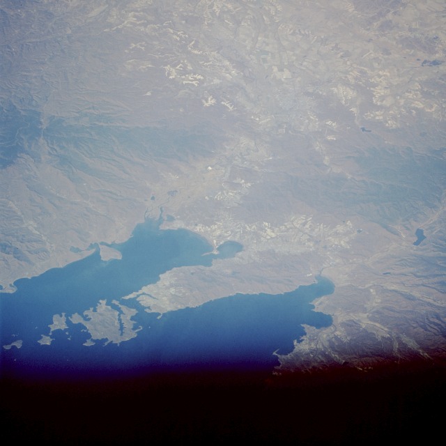 |
| STS61A-45-0072 Vladivostok, Russia November 1985 This north-northwest-looking, low-oblique photograph shows Vladivostok and the surrounding region. Russia's largest port on the Pacific Ocean, Vladivostok is located in extreme southeast Siberia near the North Korea and Manchuria borders. The harbor city, like an amphitheater on the hills around an inlet of Peter the Great Bay, sits at the southern end of the Muraview-Amurski Peninsula, which separates the Gulf of Amur to the west from Ussuri Bay to the east. Summer monsoons in combination with Siberian winters result in an unusual climate with damp springs; hot and wet summers; long, dry autumns; and frigid winters. The city is the economic and cultural center of the Russian Far East, the eastern terminus of the Trans-Siberian Railroad, and the home port for the Russian Pacific naval and fishing fleets. Major industries include shipbuilding and ship repair, fish canning, food processing, metalworking, construction, and lumber; many engineering and merchant marine colleges are located in Vladivostok. Agricultural fields of the Lake Khanka Plain are visible (northwest portion of the photograph). |
| Images: | All Available Images Low-Resolution 77k |
|
| Mission: | STS61A |
|
| Roll - Frame: | 45 - 72 |
|
| Geographical Name: | RUSSIAN FEDERATION |
|
| Features: | VLADIVOSTOK |
|
| Center Lat x Lon: | 43.5N x 132.0E |
|
| Film Exposure: | N | N=Normal exposure, U=Under exposed, O=Over exposed, F=out of Focus |
| Percentage of Cloud Cover-CLDP: | 0 |
|
| Camera:: | HB |
|
| Camera Tilt: | 48 | LO=Low Oblique, HO=High Oblique, NV=Near Vertical |
| Camera Focal Length: | 250 |
|
| Nadir to Photo Center Direction: | N | The direction from the nadir to the center point, N=North, S=South, E=East, W=West |
| Stereo?: | Y | Y=Yes there is an adjacent picture of the same area, N=No there isn't |
| Orbit Number: | 39 |
|
| Date: | 19851102 | YYYYMMDD |
| Time: | 024811 | GMT HHMMSS |
| Nadir Lat: | 40.4N |
Latitude of suborbital point of spacecraft |
| Nadir Lon: | 133.2E |
Longitude of suborbital point of spacecraft |
| Sun Azimuth: | 179 | Clockwise angle in degrees from north to the sun measured at the nadir point |
| Space Craft Altitude: | 179 | nautical miles |
| Sun Elevation: | 34 | Angle in degrees between the horizon and the sun, measured at the nadir point |
| Land Views: | HILL, PENINSULA, CAPE, PLAIN |
|
| Water Views: | BAY, GULF, INLET, RIVER |
|
| Atmosphere Views: | |
|
| Man Made Views: | URBAN AREA |
|
| City Views: | VLADIVOSTOK |
|
Photo is not associated with any sequences | ||
| NASA Home Page |
JSC Home Page |
JSC Digital Image Collection |
Earth Science & Remote Sensing |
|
This service is provided by the International Space Station program and the JSC Earth Science & Remote Sensing Unit, ARES Division, Exploration Integration Science Directorate.

|