
Geographic Region: AUSTRALIA-SA
Feature: LAKE ALEXANDRINA
|
Geographic Region: AUSTRALIA-SA Feature: LAKE ALEXANDRINA |
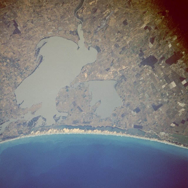 |
| STS61A-44-0055 Lake Alexandrina and Lake Albert, South Australia, Australia November 1985 Lake Alexandrina and smaller Lake Albert are located approximately 50 miles (80 kilometers) southeast of Adelaide, the capital of South Australia. Despite the fact that the Murray River and its major tributary, the Darling River, make up the most significant river network in Australia, this photograph shows an unimpressive delta as the Murray River enters the northeast side of Lake Alexandrina, which in turn empties into Encounter Bay to the west. The long, narrow sandy beach is part of Younghusband Peninsula, and the lagoon behind the beach is known as The Coorong. The Coorong and the two lakes have been identified as Ramsar Sites, critical wetland ecosystems where international attention will be focused. The major industry in this region is raising sheep--Merino sheep for wool production and fat lambs for human consumption. This area was the last part of the Australian coast to be surveyed by early explorers in the early 1800s. |
| Images: | All Available Images Low-Resolution 103k |
|
| Mission: | STS61A |
|
| Roll - Frame: | 44 - 55 |
|
| Geographical Name: | AUSTRALIA-SA |
|
| Features: | LAKE ALEXANDRINA |
|
| Center Lat x Lon: | 35.5S x 139.5E |
|
| Film Exposure: | N | N=Normal exposure, U=Under exposed, O=Over exposed, F=out of Focus |
| Percentage of Cloud Cover-CLDP: | 0 |
|
| Camera:: | HB |
|
| Camera Tilt: | 23 | LO=Low Oblique, HO=High Oblique, NV=Near Vertical |
| Camera Focal Length: | 250 |
|
| Nadir to Photo Center Direction: | SE | The direction from the nadir to the center point, N=North, S=South, E=East, W=West |
| Stereo?: | Y | Y=Yes there is an adjacent picture of the same area, N=No there isn't |
| Orbit Number: | 51 |
|
| Date: | 19851102 | YYYYMMDD |
| Time: | 220819 | GMT HHMMSS |
| Nadir Lat: | 34.4S |
Latitude of suborbital point of spacecraft |
| Nadir Lon: | 138.9E |
Longitude of suborbital point of spacecraft |
| Sun Azimuth: | 88 | Clockwise angle in degrees from north to the sun measured at the nadir point |
| Space Craft Altitude: | 180 | nautical miles |
| Sun Elevation: | 29 | Angle in degrees between the horizon and the sun, measured at the nadir point |
| Land Views: | COAST, PENINSULA, PLAIN |
|
| Water Views: | RIVER, BAY, LAGOON |
|
| Atmosphere Views: | |
|
| Man Made Views: | AGRICULTURE |
|
| City Views: | |
|
Photo is not associated with any sequences | ||
| NASA Home Page |
JSC Home Page |
JSC Digital Image Collection |
Earth Science & Remote Sensing |
|
This service is provided by the International Space Station program and the JSC Earth Science & Remote Sensing Unit, ARES Division, Exploration Integration Science Directorate.

|