
Geographic Region: AUSTRALIA-SA
Feature: FLEURIEU PENINSULA
|
Geographic Region: AUSTRALIA-SA Feature: FLEURIEU PENINSULA |
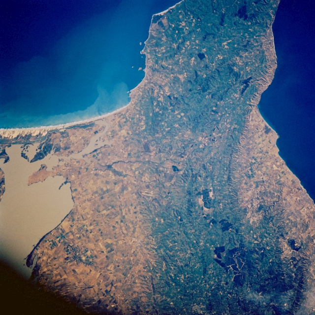 |
| STS61A-44-0053 Fleurieu Peninsula, South Australia, Australia November 1985 The green, forested, low mountains of the Fleurieu Peninsula present an appealing landscape in southeastern South Australia. The gently curving mountains with maximum elevations exceeding 1400 feet (427 meters) above sea level are situated between Adelaide (just off the edge of the scene to the north) and the western extent of the coastal, sandy beaches of Younghusbands Peninsula (to the southeast). This region enjoys a mild Mediterranean climate which supports numerous vineyards. The muddy-looking body of water along the edge of the image is Lake Alexandrina, which connects the Murray River with the Indian Ocean. The dark blue waters of the Gulf of St. Vincent is visible along the opposite (western) edge of the picture. |
| Images: | All Available Images Low-Resolution 377k |
|
| Mission: | STS61A |
|
| Roll - Frame: | 44 - 53 |
|
| Geographical Name: | AUSTRALIA-SA |
|
| Features: | FLEURIEU PENINSULA |
|
| Center Lat x Lon: | 35.5S x 138.5E |
|
| Film Exposure: | N | N=Normal exposure, U=Under exposed, O=Over exposed, F=out of Focus |
| Percentage of Cloud Cover-CLDP: | 0 |
|
| Camera:: | HB |
|
| Camera Tilt: | 13 | LO=Low Oblique, HO=High Oblique, NV=Near Vertical |
| Camera Focal Length: | 250 |
|
| Nadir to Photo Center Direction: | S | The direction from the nadir to the center point, N=North, S=South, E=East, W=West |
| Stereo?: | Y | Y=Yes there is an adjacent picture of the same area, N=No there isn't |
| Orbit Number: | 51 |
|
| Date: | 19851102 | YYYYMMDD |
| Time: | 220811 | GMT HHMMSS |
| Nadir Lat: | 34.8S |
Latitude of suborbital point of spacecraft |
| Nadir Lon: | 138.5E |
Longitude of suborbital point of spacecraft |
| Sun Azimuth: | 88 | Clockwise angle in degrees from north to the sun measured at the nadir point |
| Space Craft Altitude: | 180 | nautical miles |
| Sun Elevation: | 28 | Angle in degrees between the horizon and the sun, measured at the nadir point |
| Land Views: | PENINSULA, MOUNTAIN, FOREST |
|
| Water Views: | LAKE, GULF, OCEAN |
|
| Atmosphere Views: | |
|
| Man Made Views: | |
|
| City Views: | |
|
Photo is not associated with any sequences | ||
| NASA Home Page |
JSC Home Page |
JSC Digital Image Collection |
Earth Science & Remote Sensing |
|
This service is provided by the International Space Station program and the JSC Earth Science & Remote Sensing Unit, ARES Division, Exploration Integration Science Directorate.

|