Geographic Region: JAPAN
Feature: MOUNT FUJI
|
Geographic Region: JAPAN Feature: MOUNT FUJI |
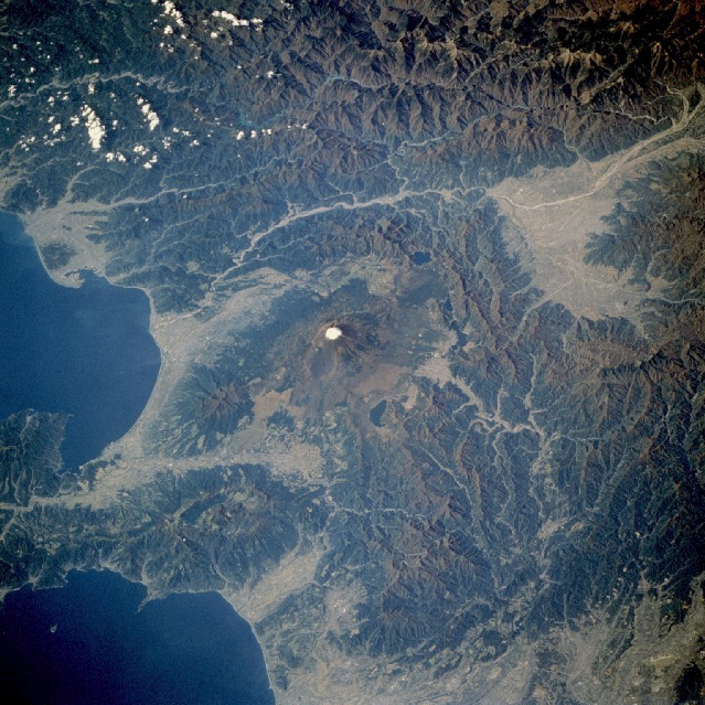 |
| STS61A-044-0100 Mount Fuji, Honshu, Japan November 1985 Snow-topped Mount Fuji, ringed by lakes and forests, is observable near the center of this low-oblique photograph taken over central Honshu, Japan. Mount Fuji, approximately 12 390 feet (3800 meters) above sea level, is located about 70 miles (110 kilometers) west-southwest of Tokyo. This volcanic peak, the tallest in Japan, is considered a sacred mountain by the Japanese. The snow-capped, symmetrical cone volcano, with a crater diameter of nearly 2 000 feet (610 meters), last erupted in 1707. The Fuji River flows west of Mount Fuji toward the interior where it passes through the city of Kofu, north-northwest of the volcano. Visible east-southeast of Mount Fuji is the Hokone caldera, which is 6 miles (10 kilometers) wide. The scene captured in this photograph is typical of the topography of the four largest islands of Japan--Hokkaido, Honshu, Shikoku, and Kyushu. Because the Japanese archipelago is volcanic in origin, less than 20 percent of the land is habitable, and farmland is limited and regionally fragmented. |
| Images: | All Available Images Low-Resolution 172k |
|
| Mission: | STS61A |
|
| Roll - Frame: | 44 - 100 |
|
| Geographical Name: | JAPAN |
|
| Features: | MOUNT FUJI |
|
| Center Lat x Lon: | 35.5N x 139.0E |
|
| Film Exposure: | N | N=Normal exposure, U=Under exposed, O=Over exposed, F=out of Focus |
| Percentage of Cloud Cover-CLDP: | 5 |
|
| Camera:: | HB |
|
| Camera Tilt: | 43 | LO=Low Oblique, HO=High Oblique, NV=Near Vertical |
| Camera Focal Length: | 250 |
|
| Nadir to Photo Center Direction: | W | The direction from the nadir to the center point, N=North, S=South, E=East, W=West |
| Stereo?: | N | Y=Yes there is an adjacent picture of the same area, N=No there isn't |
| Orbit Number: | 54 |
|
| Date: | 19851103 | YYYYMMDD |
| Time: | 013220 | GMT HHMMSS |
| Nadir Lat: | 36.2N |
Latitude of suborbital point of spacecraft |
| Nadir Lon: | 141.7E |
Longitude of suborbital point of spacecraft |
| Sun Azimuth: | 166 | Clockwise angle in degrees from north to the sun measured at the nadir point |
| Space Craft Altitude: | 178 | nautical miles |
| Sun Elevation: | 37 | Angle in degrees between the horizon and the sun, measured at the nadir point |
| Land Views: | VOLCANO, MOUNTAIN, FAULT, CRATER |
|
| Water Views: | |
|
| Atmosphere Views: | |
|
| Man Made Views: | |
|
| City Views: | |
|
Photo is not associated with any sequences | ||
| NASA Home Page |
JSC Home Page |
JSC Digital Image Collection |
Earth Science & Remote Sensing |
|
This service is provided by the International Space Station program and the JSC Earth Science & Remote Sensing Unit, ARES Division, Exploration Integration Science Directorate.

|