
Geographic Region: ETHIOPIA
Feature: DANAKIL DEPR., AFRERA L.
|
Geographic Region: ETHIOPIA Feature: DANAKIL DEPR., AFRERA L. |
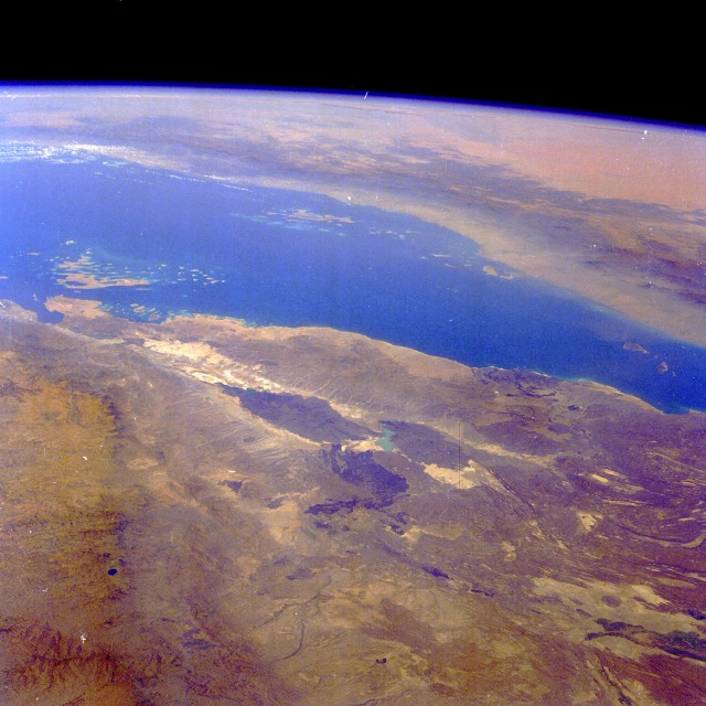 |
| STS61A-43-0042 Denakil Desert, Eritrea and Ethiopia November 1985 The Denakil Desert, one of the most hostile environments in the world, can be seen in this high-oblique, northeast-looking photograph. This part of the great Rift Valley, known as the Afar Triangle, stretches north-south 350 miles (570 kilometers), varying in width from 50 to 250 miles (80 to 400 kilometers). Bounded on the north and east by the Red Sea and on the west by the highlands of Ethiopia (both visible in the photograph), much of this extremely hot and dry desert is below sea level. Erta Alle (dark gray area near the center of the photograph), a large shield volcano referred to as the "smoking volcano" by local tribesmen, has been in a constant state of eruption since the late 1960s. Just north of Erta Alle Volcano are the Dalol Salt Flats. Formerly a shallow lake, the area now sits 400 feet (120 meters) below sea level and is covered with salt deposits, some of which are estimated to be 3 miles (5 kilometers) thick. Across the Red Sea, the Hijaz Mountains are visible. Beyond these mountains are the northwestern portions of the Empty Quarter Desert of Saudi Arabia. The Denakil is a great example of the forces of nature at work, altering and changing the landscape. |
| Images: | All Available Images Low-Resolution 122k |
|
| Mission: | STS61A |
|
| Roll - Frame: | 43 - 42 |
|
| Geographical Name: | ETHIOPIA |
|
| Features: | DANAKIL DEPR., AFRERA L. |
|
| Center Lat x Lon: | 14.0N x 41.0E |
|
| Film Exposure: | N | N=Normal exposure, U=Under exposed, O=Over exposed, F=out of Focus |
| Percentage of Cloud Cover-CLDP: | 0 |
|
| Camera:: | HB |
|
| Camera Tilt: | HO | LO=Low Oblique, HO=High Oblique, NV=Near Vertical |
| Camera Focal Length: | 100 |
|
| Nadir to Photo Center Direction: | N | The direction from the nadir to the center point, N=North, S=South, E=East, W=West |
| Stereo?: | Y | Y=Yes there is an adjacent picture of the same area, N=No there isn't |
| Orbit Number: | 42 |
|
| Date: | 19851102 | YYYYMMDD |
| Time: | 071110 | GMT HHMMSS |
| Nadir Lat: | 8.7N |
Latitude of suborbital point of spacecraft |
| Nadir Lon: | 38.7E |
Longitude of suborbital point of spacecraft |
| Sun Azimuth: | 128 | Clockwise angle in degrees from north to the sun measured at the nadir point |
| Space Craft Altitude: | 175 | nautical miles |
| Sun Elevation: | 52 | Angle in degrees between the horizon and the sun, measured at the nadir point |
| Land Views: | VOLCANO, RIFT, FAULT, VALLEY, COAST, ESCARPMENT |
|
| Water Views: | SEA |
|
| Atmosphere Views: | |
|
| Man Made Views: | |
|
| City Views: | |
|
Photo is not associated with any sequences | ||
| NASA Home Page |
JSC Home Page |
JSC Digital Image Collection |
Earth Science & Remote Sensing |
|
This service is provided by the International Space Station program and the JSC Earth Science & Remote Sensing Unit, ARES Division, Exploration Integration Science Directorate.

|