
Geographic Region: USA-LOUISIANA
Feature: MISSISSIPPI RIVER DELTA
|
Geographic Region: USA-LOUISIANA Feature: MISSISSIPPI RIVER DELTA |
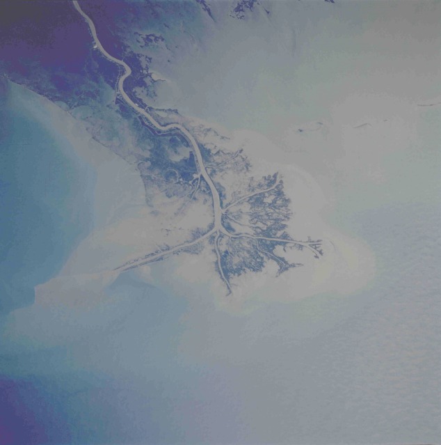 |
| STS61A-42-51 Mississippi River Delta, Louisiana, U.S.A. October 1985 The Mississippi River carries more than 200 million tons (181 million metric tons) of sediment annually past the city of New Orleans and into the Gulf of Mexico to form a fast-growing delta. This low-oblique, south-looking photograph shows the tremendous quantity of silt deposited through the distributory channel system at the southern end of the Mississippi River. This particular deposition pattern, called a "bird's foot" delta, is the only such delta in the world. Constant dredging is required for oceangoing ships to navigate the main channel of the Mississippi River. This photograph shows a dynamic scene of surface winds creating a current flow in the water, which is moving the sediment in a westerly direction. The northeastern section of the delta has been set aside as the Delta National Wildlife Refuge. State Highway 23, which eventually makes its way to New Orleans and beyond, can be seen along the western side of the main channel. (Refer to STS51C-143-27 for a more synoptic view of the delta area and its relationship to the city of New Orleans.) |
| Images: | All Available Images Low-Resolution 54k |
|
| Mission: | STS61A |
|
| Roll - Frame: | 42 - 51 |
|
| Geographical Name: | USA-LOUISIANA |
|
| Features: | MISSISSIPPI RIVER DELTA |
|
| Center Lat x Lon: | 29.0N x 89W |
|
| Film Exposure: | N | N=Normal exposure, U=Under exposed, O=Over exposed, F=out of Focus |
| Percentage of Cloud Cover-CLDP: | 0 |
|
| Camera:: | HB |
|
| Camera Tilt: | 45 | LO=Low Oblique, HO=High Oblique, NV=Near Vertical |
| Camera Focal Length: | 250 |
|
| Nadir to Photo Center Direction: | S | The direction from the nadir to the center point, N=North, S=South, E=East, W=West |
| Stereo?: | N | Y=Yes there is an adjacent picture of the same area, N=No there isn't |
| Orbit Number: | 95 |
|
| Date: | 19851105 | YYYYMMDD |
| Time: | 154334 | GMT HHMMSS |
| Nadir Lat: | 31.7N |
Latitude of suborbital point of spacecraft |
| Nadir Lon: | 90.1W |
Longitude of suborbital point of spacecraft |
| Sun Azimuth: | 144 | Clockwise angle in degrees from north to the sun measured at the nadir point |
| Space Craft Altitude: | 177 | nautical miles |
| Sun Elevation: | 34 | Angle in degrees between the horizon and the sun, measured at the nadir point |
| Land Views: | ISLAND, COAST |
|
| Water Views: | DELTA, RIVER, CHANNEL, SEDIMENT, SWAMP |
|
| Atmosphere Views: | |
|
| Man Made Views: | |
|
| City Views: | |
|
Photo is not associated with any sequences | ||
| NASA Home Page |
JSC Home Page |
JSC Digital Image Collection |
Earth Science & Remote Sensing |
|
This service is provided by the International Space Station program and the JSC Earth Science & Remote Sensing Unit, ARES Division, Exploration Integration Science Directorate.

|