
Geographic Region: USA-TEXAS
Feature: GALVESTON BAY
|
Geographic Region: USA-TEXAS Feature: GALVESTON BAY |
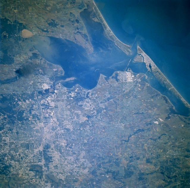 |
| STS61A-042-0046 Houston and Galveston Bay, Texas, U.S.A. November 1985 Houston, the fourth most populous city in the United States, is featured in this east-looking, low-oblique photograph. A channel dredged within Galveston Bay, whose average depth is 12 feet (4 meters), allows merchant ships and tankers to enter the Port of Houston, the third-busiest port in the United States. Galveston is discernible at the east end of Galveston Island at the entrance to Galveston Bay. Visible are reflective areas northwest of Galveston that identify large oil refinery and petrochemical plants in Texas City; rich agricultural lands of the coastal plain on either side of Galveston Bay and south of Houston; and a large smoke plume from an oil refinery fire north of Baytown in the small community of Mont Belvieu. |
| Images: | All Available Images Low-Resolution 354k |
|
| Mission: | STS61A |
|
| Roll - Frame: | 42 - 46 |
|
| Geographical Name: | USA-TEXAS |
|
| Features: | GALVESTON BAY |
|
| Center Lat x Lon: | 29.5N x 95W |
|
| Film Exposure: | N | N=Normal exposure, U=Under exposed, O=Over exposed, F=out of Focus |
| Percentage of Cloud Cover-CLDP: | 0 |
|
| Camera:: | HB |
|
| Camera Tilt: | 43 | LO=Low Oblique, HO=High Oblique, NV=Near Vertical |
| Camera Focal Length: | 250 |
|
| Nadir to Photo Center Direction: | W | The direction from the nadir to the center point, N=North, S=South, E=East, W=West |
| Stereo?: | N | Y=Yes there is an adjacent picture of the same area, N=No there isn't |
| Orbit Number: | 95 |
|
| Date: | 19851105 | YYYYMMDD |
| Time: | 154243 | GMT HHMMSS |
| Nadir Lat: | 29.1N |
Latitude of suborbital point of spacecraft |
| Nadir Lon: | 92.3W |
Longitude of suborbital point of spacecraft |
| Sun Azimuth: | 140 | Clockwise angle in degrees from north to the sun measured at the nadir point |
| Space Craft Altitude: | 177 | nautical miles |
| Sun Elevation: | 35 | Angle in degrees between the horizon and the sun, measured at the nadir point |
| Land Views: | COAST, ISLAND, PLAIN |
|
| Water Views: | BAY, GULF, CHANNEL |
|
| Atmosphere Views: | SMOKE |
|
| Man Made Views: | HIGHWAY |
|
| City Views: | |
|
Photo is not associated with any sequences | ||
| NASA Home Page |
JSC Home Page |
JSC Digital Image Collection |
Earth Science & Remote Sensing |
|
This service is provided by the International Space Station program and the JSC Earth Science & Remote Sensing Unit, ARES Division, Exploration Integration Science Directorate.

|