
Geographic Region: USA-OKLAHOMA
Feature: LAWTON
|
Geographic Region: USA-OKLAHOMA Feature: LAWTON |
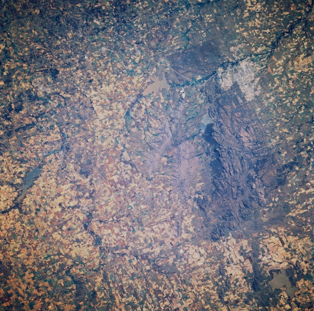 |
| STS61A-041-0085 Wichita Mountains and Lawton, Oklahoma, U.S.A. November 1985 The Wichita Mountains, an outlier of the Ouachitas of western Arkansas, are featured in this east-southeast-looking, low-oblique photograph. Domed sedimentaries were eroded, and the Wichitas are now composed of mostly igneous rocks, chiefly granites. The uplifted and base-leveled mountains have much in common with the Great Appalachians east of the Mississippi River. A large portion of the Wichita Mountains is a National Wildlife Refuge. Lawton, east-southeast of the Wichita Mountains, is a trade and commercial center for the surrounding cotton, wheat, and cattle area of southwestern Oklahoma. Industries include clothing, cement, and dairy products; limestone quarrying, and oil well production. The city also supports nearby Fort Sill, a U.S. Army Field Artillery Center. Visible north of Lawton are sediment-laden Lake Ellsworth and Fort Cobb Lake (left center). |
| Images: | All Available Images Low-Resolution 437k |
|
| Mission: | STS61A |
|
| Roll - Frame: | 41 - 85 |
|
| Geographical Name: | USA-OKLAHOMA |
|
| Features: | LAWTON |
|
| Center Lat x Lon: | 35.0N x 98.5W |
|
| Film Exposure: | N | N=Normal exposure, U=Under exposed, O=Over exposed, F=out of Focus |
| Percentage of Cloud Cover-CLDP: | 0 |
|
| Camera:: | HB |
|
| Camera Tilt: | 23 | LO=Low Oblique, HO=High Oblique, NV=Near Vertical |
| Camera Focal Length: | 250 |
|
| Nadir to Photo Center Direction: | SE | The direction from the nadir to the center point, N=North, S=South, E=East, W=West |
| Stereo?: | N | Y=Yes there is an adjacent picture of the same area, N=No there isn't |
| Orbit Number: | 80 |
|
| Date: | 19851104 | YYYYMMDD |
| Time: | 165920 | GMT HHMMSS |
| Nadir Lat: | 35.9N |
Latitude of suborbital point of spacecraft |
| Nadir Lon: | 99.4W |
Longitude of suborbital point of spacecraft |
| Sun Azimuth: | 155 | Clockwise angle in degrees from north to the sun measured at the nadir point |
| Space Craft Altitude: | 178 | nautical miles |
| Sun Elevation: | 35 | Angle in degrees between the horizon and the sun, measured at the nadir point |
| Land Views: | MOUNTAIN, PLAIN |
|
| Water Views: | LAKE |
|
| Atmosphere Views: | |
|
| Man Made Views: | URBAN AREA, AGRICULTURE |
|
| City Views: | LAWTON |
|
Photo is not associated with any sequences | ||
| NASA Home Page |
JSC Home Page |
JSC Digital Image Collection |
Earth Science & Remote Sensing |
|
This service is provided by the International Space Station program and the JSC Earth Science & Remote Sensing Unit, ARES Division, Exploration Integration Science Directorate.

|