
Geographic Region: USA-TEXAS
Feature: O'DONNELL
|
Geographic Region: USA-TEXAS Feature: O'DONNELL |
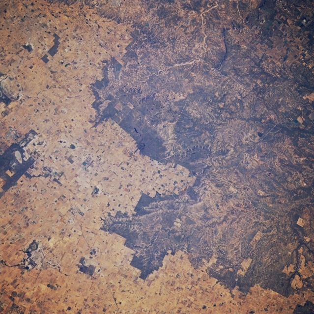 |
| STS61A-041-0082 Caprock Escarpment, Texas, U.S.A. November 1985 The north-south-oriented Caprock escarpment, separating the high plains from erosional lands of the Permian Plain, is featured in this northeast-looking, low-oblique photograph. Though not a high escarpment, the differences in landscape and land use on either side of the escarpment are apparent. Barely discernible is four-lane U.S. Highway 87, which connects Big Spring and Lubbock. |
| Images: | All Available Images Low-Resolution 400k |
|
| Mission: | STS61A |
|
| Roll - Frame: | 41 - 82 |
|
| Geographical Name: | USA-TEXAS |
|
| Features: | O'DONNELL |
|
| Center Lat x Lon: | 33.0N x 101.5W |
|
| Film Exposure: | N | N=Normal exposure, U=Under exposed, O=Over exposed, F=out of Focus |
| Percentage of Cloud Cover-CLDP: | 0 |
|
| Camera:: | HB |
|
| Camera Tilt: | 12 | LO=Low Oblique, HO=High Oblique, NV=Near Vertical |
| Camera Focal Length: | 250 |
|
| Nadir to Photo Center Direction: | E | The direction from the nadir to the center point, N=North, S=South, E=East, W=West |
| Stereo?: | Y | Y=Yes there is an adjacent picture of the same area, N=No there isn't |
| Orbit Number: | 80 |
|
| Date: | 19851104 | YYYYMMDD |
| Time: | 165823 | GMT HHMMSS |
| Nadir Lat: | 33.1N |
Latitude of suborbital point of spacecraft |
| Nadir Lon: | 102.1W |
Longitude of suborbital point of spacecraft |
| Sun Azimuth: | 151 | Clockwise angle in degrees from north to the sun measured at the nadir point |
| Space Craft Altitude: | 178 | nautical miles |
| Sun Elevation: | 36 | Angle in degrees between the horizon and the sun, measured at the nadir point |
| Land Views: | PLAIN, ESCARPMENT |
|
| Water Views: | |
|
| Atmosphere Views: | |
|
| Man Made Views: | HIGHWAY |
|
| City Views: | |
|
Photo is not associated with any sequences | ||
| NASA Home Page |
JSC Home Page |
JSC Digital Image Collection |
Earth Science & Remote Sensing |
|
This service is provided by the International Space Station program and the JSC Earth Science & Remote Sensing Unit, ARES Division, Exploration Integration Science Directorate.

|